

Astronomical date of the "observatory" at Taosi site
Preface
Covering an area of about 300 ha, the Taosi site is located in the northeast of the Xiangfen County, Shanxi Province. From the late 1970s to the early 1980s, the archaeological team of the IACASS had excavated residences of common people and an elite cemetery at the site. The fruitful discoveries resulted in the establishment of the Taosi Culture (4,300 to 3,900 BP ). From the 9 tombs of chiefs (perhaps the kings) of the Early Taosi period, were found a number of distinctive ritual objects, such as the ceramic plate with painted dragon design, ceramic drums, drums with crocodile skin made membrane, chime stones, ceremonial wooden wares, jade and stone axes (Chang 1986), which might indicate the emergence of a “kingdom”.
From 1999 to 2001, archaeologists from the IACASS found a gigantic rammed-clay- enclosure of the Middle Taosi period (4,100 to 4,000 BP). Rectangular in form with an inner area of 280 ha, it makes the Taosi site the largest walled-town in prehistoric China.
In 2002, the archaeological work at Taosi was involved into the “Settlement Pattern and Social Transformation” project – a sub-project of the “Initial Research on Chinese Civilization” project. The fieldwork has discovered the rammed clay enclosure of the Early Taosi period (4300 to 4100 BP), palace area, aristocratic cemetery, and storage area (He Nu, Yan Zhibin & Song Jianzhong, 2003; IA of CASS et al. , 2003).
Latest discoveries
From 2003 to 2004, archaeologists from the IACASS, the Shanxi Provincial Institute of Archaeology, and the Cultural Relics Bureau of Linfen Prefecture, unearthed a Middle Taosi period semi-round foundation – IIFJT1 just beside southern wall Q6 of the Middle Taosi enclosure (IACASS et al., 2004). It is consists of an outer semi-ring-shaped path and a semi-round rammed- earth platform with a diameter of about 60 m. and an area of nearly 1700 sq m(Plate 1). The platform is 42m in diameter and over 1000 sq m in area. It can be reconstructed as a three-level altar. The outer first level is crescent in shape and 23 to 30 m to the center of the altar. The second level in the middle is semi-ring in shape and 19 to 21 m from the center. The third level or the top of the altar is semi-round in shape and around 13 m from the center.
An arch-shaped rammed earth foundation facing the east with 12 slots, each 0.15 to 0.2 m wide and 1.4 m between each other were discovered on the top of the altar (Plate 2). Certain features of the slots indicate that stone or wooden posts in rectangle or trapeziform shape might have been erected on the rammed earth foundation with slots between them.
Standing in the center of the altar and watching through the slots, one can find that most of slots respectively orientate to a given point of the Chongfen Mountain to the east. Therefore, a reasonable inference is that the slots might have been intentionally constructed in for astronomic observation of the sunrise on a particular point in a given day in order to establish the local solar calendar which is crucial for the practice of agriculture at that time. In other words, the altar is an observatory.
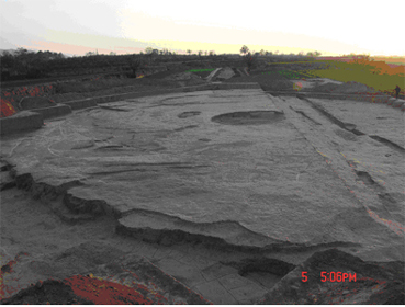
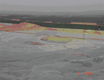
Plate 1 An overview of the IIFJT1 (Form east to west) (left)
Plate 2 The foundation with slots on the top of the altar (From southeast to northeast) (right)
The latest discovery of the original observation point at the core of the altar further proves our previous inference. It is a round pit with one round rammed earth core and two rings of rammed earth surrounding the core. The pit is 145 cm, the outer ring is 86cm., the inner ring is 42 cm., the core is 25 cm in diameter. There is only a 4 cm bias between the point and our estimative point before the discovery.
Test observations
In order to test our hypothesis that the altar functioned as an observatory, we have observed for 45 times the sunrise from midwinter in 2003 to midwinter in 2004.
On December 22, 2003, the day of winter solstice, we observed from the 0.25 (inner) to 0.3 (outer) m wide Slot 2 between post D9 and D10. It just focuses to the Peak S8 of the Chongfen Mountain with an azimuth angle of 130°30′(Plate 3~4).
Plate 3 Photo by He Nu Plate 4 Photo by He Nu
At 8:17:38 a.m., we saw the half sunrise on the northern foot of Peak S8 (Plate 5). It came out neither on the top of the Peak S8 nor in the middle of Slot 2. At 8:23:48 a.m., the sun was in the center of Slot 2, above the top of Peak S8 (Plate 6). Hence the time difference from semi-appearance to entirely sunrise is ⊿τ = 6 m 10 s = 1° 32′ 30″ (Fig .1, Table 1).

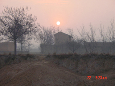
Plate 5 Half Sunrise on Dec. 22, 2003 Plate 6 Sunrise on Dec. 22, 2003
Table 1 Observation Record of Winter Solstice (2003.12.22) 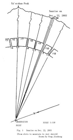
Observation Time Whether in Pattern of Sunrise
Eastern Slot 2
8:17:38 outside semi-appearance
8:23:38 in center above the top of the peak
2. Analysis
According to the observation, we realized that the semi-sunrise on winter solstice is close to the north side of Slot 2, but not in it. About 6 minutes and 10 seconds later, as the sun rose above the top of Peak S8, it got into the slot, however, the bottom fringe of the sun had left the top of the peak. However, midwinter sunrise in a given period in the past might have been on the top of the peak while it was in the middle of the slot. Hence the Eastern Slot 2 could still be regarded as the observation slot for midwinter sunrise in prehistoric period. The position bias is probably caused by the change of obliquity of the ecliptic.
Astronomical date
As we know, the earth revolution is effected by planet perturbation, resulting a little change of its revolution orbit plane — ecliptic plane and position of ecliptic pole, which is called as “planetary precession ”, which can result in the change of obliquity of the ecliptic (ε). Such a change is periodicity. The maximum obliquity of the ecliptic (ε) could reach to 24.24°, the minimum one to 22.1°. Such a changing cycle takes nearly 40,000 years. Recently ecliptic pole is accessing to the celestial pole, the obliquity of the ecliptic approximately reduces 47″ (arc-seconds) per century. The reducing would still persist 15,000 years. And then it would turn to increase. In 1901, Mr. Simon Newcomb, an American astronomer, put forward the calculation formula—the famous “Newcomb Formula ”. Based on the formula one can evaluate the changing quantity (⊿ε) of obliquity of the ecliptic in historic period. On winter solstice, the declination gets to the southernmost (δ = - ε). Therefore the changing quantity of declination (⊿δ) is equivalent to the one of obliquity of the ecliptic (⊿ε). The change of sunrise azimuth angle (A) is resulted by the solar declination, which (⊿A ) could be determined by testing observation and relative calculation. Therefore, by observing ⊿A, one can reckon the construction and design date for the Taosi observatory. That is its astronomic date.
As what is illustrated in Fig. 2, in the midwinter morning, as we looked toward southeast from the observing point, the sun centered at point A. Six minutes and ten seconds later, the center of the sun came up to the point D which was right in the middle of Slot 2.
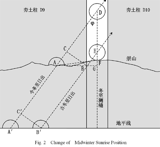
So AD was right on the solar declination circle. From D we draw a vertical to the top of Peak S8. The vertical ends at point F. Thus ∠ADF = φ = 35° 52′ 55.8″. In the Middle Taosi period, the midwinter sunrise centered at point E, while its lower fringe cut the top of the Peak S8 at point F. Hence EF is solar apparent radius. Taking into account for average apparent radius of the sun, EF = 16′. From A we draw a vertical crossing the extending line of DF at point G. From point E we draw a parallel crossing the line of AG at point B. From B we draw a vertical crossing AD at point C, then BC =⊿δ =⊿ε. Therefore, AD =⊿τ = 1° 32′ 30″,AB =⊿A. There is an angle between AF ( from the center of semi-sunrise to the top of the peak ) and horizon, which is measured as ∠FAG = 6° by means of photograph.
Analyzing spherical surface right-angled triangles (they could be approximately considered as plane right-angled triangles ), ⊿ADG、⊿AFG、⊿BFG, the resolution is as follow.
AG = sin–1(sin φ sin⊿τ)= sin–1(sin35° 52′ 55.8″ × sin1° 32′ 30″⊿τ)= 54′ 12.709″
FG = tan–1(sinAG × tan∠FAG)= tan–1(sin54′ 12.709″ × tan6°)= 5′ 41.859″
BG = tan–1[sin(EF + FG) × tanφ]= tan–1[sin(16′ + 5′ 41.859″) × tan35.882°]= 15′ 41.759″
⊿A= AB = AG - BG = 54′ 12.709″ - 15′ 41.759″= 38′ 30.95″
The above reckon lies in the hypothesis that midwinter sunrise in the Middle Taosi period was right in the middle of Slot 2, and the lower fringe of the sun just cut the top of the Peak S8. Given such a basic presume, theoretical reckon indicates that horizonal point of winter solstice’s sunrise in the Middle Taosi period is localized about 38′ 30.95″ south to present point.
The changing quantity of the obliquity of the eclipticΔεcould be determined with ⊿A, which is directly related to the astronomic date of the structure. In order to simplifying the calculation, we consider ⊿A and ⊿ε as horizonal sunrise. Such an ideal situation is equivalent to the one on the peak. Illustrated in Fig. 2, AD is extended to cross the horizon at point A’. From B we draw a parallel to AD, and crossing the horizon at point B’. Then A’ is the center of the sun of horizontal midwinter sunrise in nowadays, and B’ was the one of Middle Taosi period. Then
⊿A = A′B′ = AB = 38′ 30.95″
⊿ε =⊿δ = B′C′ = BC.
We just deal with the horizontal midwinter sunrise.
The azimuth angle of sun appearing and disappearing on horizon could be obtained with counterchange formula of coordinates.
sinδ = sinφ cosz – cosφ sinz cosA.
The presume is the azimuth as the lower fringe of sun cuts the top of the peak. It ignores the influence from the solar apparent radius. In addition, ⊿A is a dispersion, so astronomical refraction error could be mutually counteracted. Given the distance of zenith z = 90°, the azimuth formula of sunrise and sunset is
cosA = –sinδ / cosφ.
Supposing that the azimuth of midwinter sunrise at A’ and B’ are respectively A1and A2, solar declination respectively are δ1、δ2, then
⊿A = A2 - A1,⊿δ = δ1 - δ2.
Taking ε = 23° 26′ 21.448″ (J2000.0), then δ1 = -ε = -23° 26′ 21.448″
A1 = cos–1 (–sinδ1 / cosφ) = cos–1[–sin (-23° 26′ 21.448″) / cos 35° 52′ 55.8″]= –60° 36′ 0.259″
A2 = A1+⊿A = -60° 36′ 0. 259″ + 38′ 30.95″ = -59°.57′ 29.309″
δ2 = sin–1(– cosA2 cosφ) = sin–1[–cos(-59°.57′ 29.309″) × cos35° 52′ 55.8″] = -23° 55′ 48.979″
⊿δ = δ1 - δ2 = - 23° 26′ 21.448″ - (-23° 55′ 48.979″)= 29′ 27.531″
Reckoning the Newcomb Formula as standard calendar 2000.0 as new attribute, the formula of obliquity of the ecliptic (Astronomical Calendar,1999; Hu zhongwei & Xiao Naiyuan, 2003) is
ε = 23° 26′ 21.448″ - 46.815″ T- 0.00059″ T 2 + 0.001813″ T 3.
Within the formula, T means the number of centuries before standard epoch 2000.0, then the changing quantity of obliquity of the ecliptic (⊿ε) namely the changing quantity of declination of Winter Solstice (⊿δ) is
⊿ε = 46.8150″ T + 0.00059″ T 2 - 0.001813″ T 3 =⊿δ.
Putting ⊿δ = 29′ 27.531″ into the above formula, the conclusion is
T = 40.26 .
It indicated that the astronomical date for the Taosi observatory is 4026 years before 2000.
Conclusion
Archaeoastronimic date depends both on the practical observation data and some basic presumes. Without any essential presumes, it is impossible to get the astronomical date for archaeological features. The presume of this research is that the Slot 2 might have served to observe the midwinter sunrise. As the sunrise appeared right in the middle of the Slot 2, Taosi natives considered the day as winter solstice. This presume is based on the following reasons.
Firstly, it is easy to determine the position of the midwinter sunrise by naked-eye observation. Standing on the same observing point, the sunrise position reaches to southernmost in all year round, then it returns back to the north. People can finger out the southernmost position of sunrise, connect it to a particular indicator on the ground. Yet naked-eye observation can hardly detect any change of southernmost position of sunrise from the indicator in a given period (in 100 years). It is quite possible that ancient Taosi people marked such an astronomical directrix with the observatory in order to accurately observe the winter solstice. According to ancient texts, here were other methods to determine winter solstice, such as measuring the shortest solar shadow in the noon, observing the longest day, the heliacal rising, latency stars (fuxing),and the culminant stars (zhongxing) of evening and dawn. These methods, however, were much more complicated than the astronomical directrix applied by the Taosi people. Therefore, astronomical directrix might have been the earliest method adopted by prehistoric people for observing the celestial phenomena to identify solar term.
Secondly, many scholars believed that the Taosi walled-town was the capital of the King Yao, who is alleged as one of the greatest and most famous chiefs in Chinese legend period (before Xia and Shang Dynasties). According to some Chinese classic documents such as Yao Dian (Document of Yao ) in Shang Shu (Book of Ancient Time ) and Wudibenji ( Records for the Five Kings) in Shiji (Historic Records ), the King Yao assigned astronomic officers to observe celestial phenomena such as the sunrise, sunset, evening stars in culmination in order to make a solar and lunar calendar with 366 days for a year and a solution of leap month. The observatory found at Taosi just coincides with these records.
Thirdly, based on our experimental observations through other slots, the striking observatory can also observe other celestial phenomena to identify the solar term. We are going to introduce them in another paper.
Finally, the astronomic date based on the data yielded from our experimental observations coincided with the C 14 date of the Middle Taosi period – the astronomical date is 4026±115 BP.4050 BP. The C14 date is around 4,100 to 4,000 BP (Table 2).
Table 2 C14 date of the Taosi site
Lab. No. Stratigraphic Unit Dendrochronologically BC
Calibration Date (BP)
ZK1086 IVT422④D 4080±95 2130±95
ZK1086 IVH420 4045±95 2095±95
ZK1085 IVT423④D 4030±95 2080±95
ZK1102 IVH419 3770±130 1820±130
Although the function of the Taosi observatory still need more investigation, currently research already provides us a new perspective to understand the Taosi period and the emergence of early states in China.
Epilogue: The archaeological field was directed by Dr. He Nu. The testing observation was organized by He Nu and carried out by Mr. Feng Jiusheng and He Nu. The figures in the paper were drawn by Feng Jiusheng and Dr. Wu Jiabi. Directed by Prof. Chen Meidong , Wu Jiabi undertook the astronomical reckon. Particularly we appreciate the support from Academician Xi Zezong, Wang Shouguan, Prof. Li Boqian, Wang Changsui, Liu Qingzhu, Liu Chun, Wang Qianjin. Prof. Chen Jiujing, Shi Yunli have made some constructive suggestions. Dr. Song Lingping re-corrected the English expression of this paper.
Bibiliography
Astronomical Calendar , 1999. Chinese Astronomical Calendar for 2000. Science Press, Beijing, p. 507.
Gao Tianlin, Zhang Daihai, Gao Wei, 1984. Chronological Dates and Phases of Taosi Type of Longshan Culture. Research on Prehistory, 1984:3. Xi’an.
He Nu, Yan Zhibin, Song Jianzhong, 2003. Taosi Walled-town in Xiangfen Unearthed Violent Evidence. China Cultrual Relics News, Jan. 31, 2003, p. 1.
Hu Zhongwei, Xiao Naiyuan, 2003. Tutorial of Astronomy . First Vol. , Higher Education Press, Beijng, 2d edition, p.116.
Hu Zhongwei, Yan Jiarong, 2003. Directory for Star Observation. Nanjing University Press, Nanjing, p. 47.
IA of CASS, et al., 2003. Tombs of the Middle Taosi Culture Discovered on the Taosi City-site. Kaogu (Archaeology) 2003:9:3-6. Beijng.
IA of CASS, et al., 2004. 2003 Excavation of the large-sized Structure Foundations in Sacrificial Area of the Taosi City-site in Xiangfen City, Shanxi. Kaogu (Archaeology ) 2004:7:9-24. Beijing.
K. C. Chang, 1986. The Archaeology of Ancient China. Fourth edition, Yale University Press, pp. 275-277.