

A Survey of Gansang site and Further Discussion
From:Chinese Archaeology NetWriter:Xu FengxianDate:2014-07-02
1. A Survey of Gansang site
On June 23rd , 2014, after visiting the Pingguo Museum, under the help of Guangxi Institute of archaeology, our team, including He Nu, Xu Fengxian and Ye Xiaohong, surveyed the surrounding mountains of Gansang Site with a total-station. The purpose is to study the astronomical environment of the site, especially the sunset points during the two solstices.
Gansang Site is located in a plain surrounded by mountains. The near mountains can be divided into 2 parts: from NNW-Due North-Due East-Due South-SSW is a chain of semi-circled mountains consisting of several peaks and valleys, we numbered the peak at the south-west end 01. To the west of the plain is a separate hill consisting of only 1 peak, which we numbered 02. Between Peak 01 and Peak 02 is a relatively wide mouth facing WWS, far away being a chain of low mountains on which 26 peaks could be discerned. We numbered the 26 peaks No.1 - No.26 from south to north (Fig 1, Fig 2). Besides the wide mouth, the semi-circled chain of mountains and the separate hill also formed another smaller mouth facing northwest, not far away outside this mouth being a single peak.
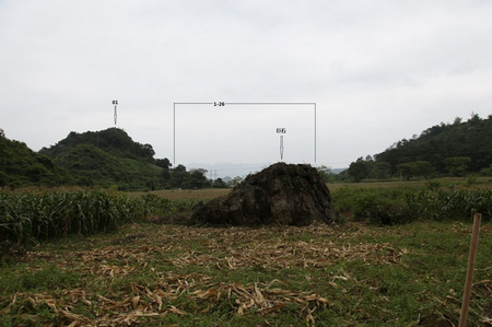
Fig. 1 The wide WWS Mouth
Inside the plain near to the east there is a stone in the shape of a chair-arm, which was evidently formed by flowing water. About 10 meters from the chair-stone to the direction of the wide mouth is an isolated huge stone. Dr. Gosline believes that the chair-stone was an ancient observational point, while the huge stone and Peak 02 acted as sunset points on winter solstice and summer solstices, respectively.
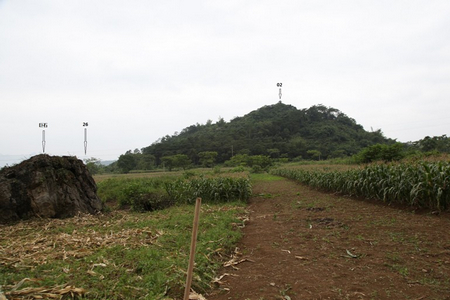
Fig. 2 Peak 02 and the huge stone
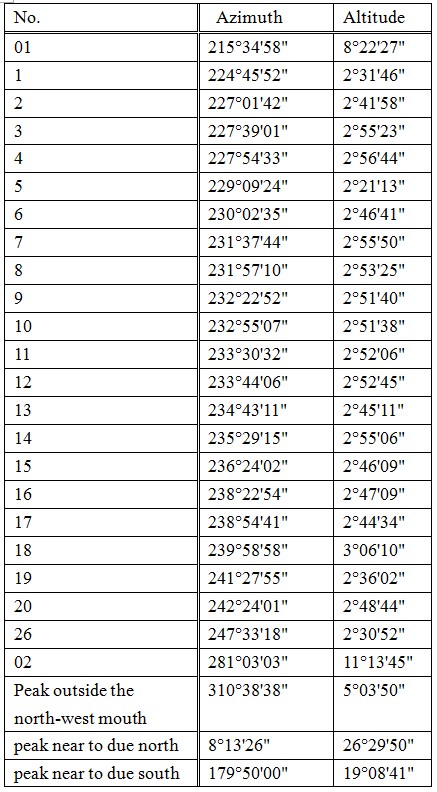
In our survey the chair-stone was used as the base point. The targets of the survey included the chain of far mountains outside the WWS mouth, the peak at the south side of the mouth (ie. Peak 01) and that at the north side of the mouth ( ie. Peak 02), the two peaks that nearest to due north and due south, and the peak outside the northwest mouth. Among the 26 peaks far away outside the wide WWS mouth No. 21 to No. 25 were blocked by the near huge stone in the visual field of the total-station and could not be surveyed. Thus 26 targets were surveyed totally. We measured the azimuth and the altitude of each of the 26 points.
Geographic coordinate was got by a GPS as: N23°21'58.33",E107°30'54.33". Table 1 shows the results of the survey.
Table 1 The survey results of Gansang site
2. Analyzation of the survey results
Azimuths of sunset at the 2 solstices are calculated with Skymap software preliminarily. The altitudes should be taken into consideration because of the mountains.
Magnetic declination should be considered, too. This value is around 2° in Pingguo County. The data obtained by a total-station inevitably contain magnetic declination, thus the preliminary calculating results in the following contain the magnetic declination, too.
Variation of the obliquity of the ecliptic affects the azimuth of sunset. The obliquity of the ecliptic for bronze-age is about 30′ bigger than that of today, which should be taken into consideration. So the 2 years of AD2014 and 1600BC are chosen to be calculated.
Peak 02, whose azimuth is 281°03'03" and altitude 11°13'45" according to our survey, is the so-called summer sunset peak by Dr. Gosline. In checking if this peak is really summer sunset point I tried to find the azimuth of the sun when its altitude is around 11°13'45" on summer solstice in both AD2014 (21st June) and 1600BC (7th July). I also gave the azimuth of the setting sun supposing no mountains on the horizon. The results are shown in Table 2 and Table 3.
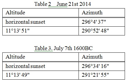
Comparing the azimuth of 281°03'03" for Peak 02 to 290°52' 48" for 2014AD and 291°21' 55" for 1600BC, it is clear that Peak 02 is quite far away from the sunset point even if the 2° of magnetic declination is taken into account. The azimuth and altitude of the isolated peak outside the northwest mouth is 310°38'38" and 5°03'50", respectively, which is quite north from the sunset point on summer solstice. So the sun should set somewhere between the north slope of the isolated west hill and the northwest mouth.
The same calculations were carried out for the winter solstice. The sunset point is on the chain of the far mountain outside the southwest mouth, whose altitude is around 2°-3° with only 1 exception, No.18, 3°06'10" in height. So the sun’s azimuths in two situations are calculated: one being that the sun’s altitude is around 2°, the other the sun’s altitude around 3°. Table 4 and Table 5 show the results.
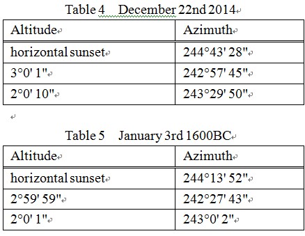
The data of No. 20 is 242°24'01",2°48'44", very near to winter solstice. No.21-No.25 peaks are blocked by the rising north part of the huge stone, while No. 20 is behind the lower south part of the huge stone thus not blocked by it. So on winter solstice the sun really set in the direction of the huge stone.
Even so I don’t agree that the huge stone could have been used as sunset point on winter solstice. First, the stone is very rough without any artificial evidence on it. Secondly, the huge stone is too near to the chair-stone, the so-called observational point, thus parallax would affect the observational results severely, making the stone unfit for acting as an observational background. In fact, No. 21- No. 25 peaks was blocked in the visual field of the total-station only because that the station was set a little bit low. Ordinary person could see No.21-No.25 so long as he/she stands straight. On the other hand, when plants grow prosperously on the huge stone all the peaks behind the stone would be blocked (Fig 3). The plants on the stone were cut on 22nd during our inspection, so on 23rd when we surveyed the site there were no plants on the huge stone.

Fig. 3 The huge stone with plants on it
For a stone even plants on whose top could affect the observational results seriously, it’s impossible to be used as an observational background in ancient time.
3. Further Discussion
Among the 3 places of Gansang, Nadou and Bupeng, Why did we choose only Gansang to survey? Because natural elongated objects or a line between to objects always aligns to certain direction. To confirm that certain natural alignment had been used in astronomical observation by ancient people, the first step must be to confirm that there is archaeological site around. Among the 3 places above only Gansang is an archaeological site.
In 2009 and 2012 we inspected and surveyed astronomical environments of more than 10 Neolithic sites in China, in an effort to find the sun’s rising and setting points on special dates. Method for determination of the seasons in Classic China was to measure the sun’s shadow at noon with a gnomon. Before the gnomon was used there had lasted a long time when observation of the sun’s rising and setting position was used to determine the seasons, as recorded by Chinese text such as Shanhaijing. Taosi Observatory is the culmination of this kind of observation, where artificial system was combined with outline of mountains. We choose to survey sites with definite archaeological contexts, especially sites with religious importance, such as Dongshanzui Site of Hongshan Culture and Huiguanshan Site of Liangzhu Culture.
Elongated natural objects are everywhere, and line between two natural objects can align to any direction. In case where no concrete archaeological evidences are found, there is no need to study alignment of an elongated natural object or a line between two natural objects from archaeo-astronomical view, even if they align to certain special astronomical directions. I don’t agree to take out an archaeological excavation plan on a place only because alignment to certain astronomical direction is found in the natural objects there. Even if artificial evidences are found, attention should be paid to its dating.
By Xu Fengxian (Institute for the History of Natural Science, CAS)