

The History of Urbanism at Angkor – A Giant Low-Density City
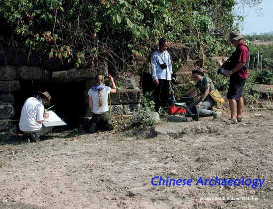
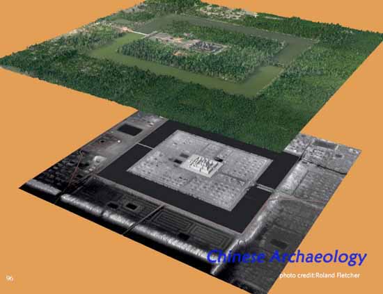
The Greater Angkor Project is an international collaboration of the University of Sydney -Australia, APSARA - the Cambodian agency that manages Angkor, and the EFEO (Ecole Francaise d'Extrême Orient) – France. The development of urbanism in SE Asia and the understanding the growth and demise of the city of Angkor between the 7th and the 16th century CE, has been redefined by introducing the concept of dispersed, low-density urbanism into the study of agrarianased societies. Methods ranging from high-altitude remote sensing such as AIRSAR and LiDAR, through ground surveys, excavation, dendrochronology, palynology and sedimentology have been used to study the extent, spatial organisation, economic operation, development and demise of Angkor in its ecological context. The key contribution of the Greater Angkor Project has been to demonstrate that the famous temples of Angkor were surrounded by vast suburbs integrated by a road and canal network into a low-density urban complex, Greater Angkor, covering about a 1000 sq km and contained as many as 750,000 people at its peak in the 12th century. A recent LiDAR survey has also shown that the central urban area, with a road grid and numerous small domestic water tanks, extends far beyond Angkor Thom, southwards to Angkor Wat, north to Preah Khan and eastwards to the East Baray, demonstrating that the urban landscape was far more extensive than the walled central enclosure.
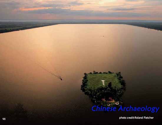
Dr Christophe Pottier of EFEO and Dr Damian Evans of the University of Sydney have produced a comprehensive map of the whole of Greater Angkor and its water catchment. Angkor had a massive and elaborate water management network for dispersing water and for distributing it to the fields, evidence that ends more than twenty years of claims to the contrary. Huge masonry structures were built to control water and the canal system is extremely sophisticated. The landscape was re-engineered for agriculture with thousands of square kilometers of rice fields. The natural forest was replaced by an anthropogenic forest of economic trees and shrubs around the numerous timber houses on their occupation mounds, along embankments and within enclosures.
The Greater Angkor Project has also show that Angkor was seriously affected by severe climatic instability in the 14th to 16th centuries. This period of interspersed mega-monsoons and mega-droughts has been identified from studies by Brendan Buckley of Columbia University on tree rings in Vietnam. In Angkor the effect is visible in massive deposits of sand that filled the southern canals in the 14th century. Severe erosion is visible in the LiDAR images of central Angkor and the Siem Reap river is today eroded down 5 to 8 m into the Angkorian ground surface. The demise of Angkor is therefore redefined and the study of this giant low-density city becomes very topical. The results transform the global implications of how large such low-density cities could become, brings together the evidence from the Maya cities of Central America and the Khmer cities of SE Asia and redefines their significance for the present day. Greater Angkor was an extensive, low- density city which cleared its landscape of natural vegetation, was dependent on an impressive and massive infrastructure, and was affected by severe climatic instability for over a century between the 14th and the 16th centuries CE. These conditions have some resonance
in the present day.
Roland Fletcher (University of Sydney)
Biographical Sketch
Roland Fletcher is Professor of Theoretical and World Archaeology at the University of Sydney. He grew up in London, England and attended St. John’s College at Cambridge University where he completed his undergraduate degree in 1970 and his PhD in 1975. He has worked at the University of Sydney since 1976 where he implemented a global, multi-scalar and interdisciplinary approach to Archaeology that integrates research, teaching and service to the community. His global research has led to extensive cross disciplinary collaboration within the University and internationally, in particular on Angkor in Cambodia. The Greater Angkor Project, which has been funded by the Australian Research Council and UNESCO is an international collaboration with the French agency EFEO and with APSARA the Cambodian government agency that manages Angkor. The project is part of the University’s Angkor Research Program of which he is Director. The program, manages a diverse range of research projects in Angkor and maintains a Research Centre in Siem Reap. As a result of his international collaborative research he has been an invited speaker and academic guest world-wide and was a Distinguished Fellow at Durham University’s Institute of Advanced Study in 2007.