

Revealing North America’s First Native City: Rediscovery and Large-Scale Excavation of Cahokia’s East St. Louis Precinct
From:Chinese Archaeology NetWriter:Thomas Eugene EmersoDate:2015-12-21
Cahokia was the earliest and greatest of the pre-European contact native polities in what is known today as the United States. This early center and its allied sites were located on the fertile floodplains and uplands of the Mississippi River near modern St. Louis in the mid-continental United States - a region marked by the conjunction of several major rivers and diverse physiographic zones. Historically this locality has been broadly known as the American Bottom.The appearance of Cahokia marks the beginning of what is known archaeologically as Mississippian culture. The Mississippian period represents the florescence of fully agricultural lifestyles, the appearance of large nucleated villages, complex forms of social and political organization typically associated with chiefdoms, the construction of massive earthen monuments, extensive trade networks, rich symbolic and religious art forms, and increasing high levels of systematic intra-polity violence. These cultural patterns, established about 1050 CE, continue to dominate the temperate forests and prairies of the Eastern United States until disrupted by 16th century CE European invasions. For some scholars, Cahokia represents the “mother culture” of these widespread Mississippian developments.
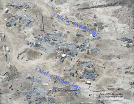
Aerial of ESTL Excavation Block
We recognize at least three great ceremonial precincts within what is often called Greater Cahokia. Cahokia and its two contiguous civic-ceremonial precincts, East St. Louis and St. Louis, formed the Central Political-Administrative core or “capital zone” of Greater Cahokia stretching along a narrow 14-km-long east-west corridor. The East St. Louis Mound precinct hugged the shoreline of the Mississippi River. In 1811 it reportedly contained 45 earthen mounds and uncounted smaller “artificial elevations” that formed a semicircle approximately one mile in extent. These mounds were situated immediately across the river from the 26 earthen pyramids of the St. Louis precinct, while connected to the east to a concentration of 120 or more tumuli at Cahokia proper via a continuous series of mounds and habitation zones. The preeminent civic-ceremonial precinct of Cahokia was dominated by an imposing 30-meter-high central earthen pyramid and a 20-hectareplus Grand Plaza. Surrounding it were public spaces, temples and elite buildings, and domestic neighborhoods. We suspect that in the eleventh and twelfth centuries CE these three ceremonial precincts were the social and political homes of important factions that were part of a larger unified urban polity.
By 800 CE, numerous small scattered farming villages, lacking any evidence of social, political, or religious administrative unity, dotted the landscape. In the mid-1000s CE a religious, social, and political event known as the Lohmann phase (1050-1100 CE) “Big Bang” signified the birth of Cahokia. Within a century (Stirling phase 1100-1200 CE) a Greater Cahokia administrativepolitical center covered an area of 14.5 km2. It subsumed at least 200 mounds, including the multi-terraced Monks Mound, the largest earthen mound ever built in what is now the United States, as well as ceremonial plazas, post-in-circle monuments, post monuments, borrow pits, dense habitation zones of elites and commoners and a population of 15,000+ inhabitants. Surrounding this core area were thousands of single-family farmsteads as well as other subsidiary civic-ceremonial mound centers. During Cahokia’s peak period of power (1050 to 1300 CE), an additional 14 multi-mound centers were located with 25 km or a day’s walk of Monks Mound. Archaeologists estimate that this metropolitan area contained about 40-50,000 inhabitants. Population growth models demonstrate that, given the relatively low pre-Mississippian population density of the American Bottom, these numbers could only have been obtained by the immigration of a large number of likely diverse groups from a wide region. The presence of a large number of immigrants has been confirmed by strontium isotope studies. By 1300-1350 CE, Greater Cahokia had collapsed and was abandoned.
Despite historical records documenting extensive pre-Columbian earthworks, many antiquarian excavations, and early 20th century CE scientific excavations, regional scholars have been reluctant to acknowledge the scale of political and social complexity at Greater Cahokia. Generally the late prehistoric native occupation of the American Bottom has been interpreted as representing numerous discrete and independent chiefly polities – similar to those observed by the first 16th European explorers in the American Southeast. The possibility that Cahokia might have been politically unified or actually urban in nature has been viewed with skepticism.
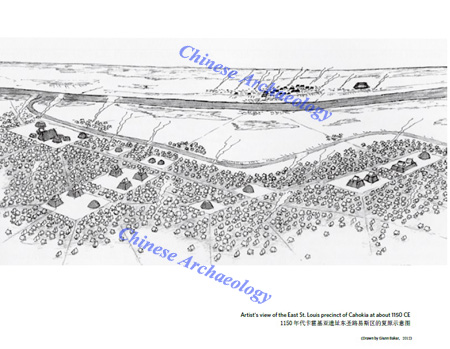
Artist's view of the East St. Louis precinct of Cahokia at about 1150 CE
To a large degree this hesitancy has been based on the large-scale destruction of Greater Cahokia caused by historic and recent development of modern St. Louis with its nearly 3 million inhabitants. By the end of the 19th century CE, the St. Louis ceremonial precinct had been totally destroyed and the 45+ mounds of the East St. Louis precinct had been leveled to the ground. Only the central precinct of Cahokia itself has been preserved into the present as a state park. Archaeologists have carried out small-scale investigations at Cahokia but no work was attempted in the other two precincts. In fact, in the 1960s a major interstate highway project through the center of the East St. Louis precinct seemingly confirmed the site’s destruction.
In the early 2000s, however, new road work in the East St. Louis precinct led to the astonishing discovery by the University of Illinois that despite massive construction and destruction, portions of the central ceremonial core of the site were still intact under the modern infrastructure of roads and buildings. These excavations uncovered portions of 79 buildings; more than 100 walls, fences, or post clusters; a compound of small storage buildings; 55 post monuments, one containing the remains of a sacrificial victim; the basal portions of 5 different earthen mounds; and several palisade segments all dating to the Mississippian period. This work was the first evidence that portions of the East St. Louis precinct might still be intact below the rubble of the modern city.
In 2008 the Illinois State Archaeological Survey initiated field excavations in an unexplored portion of the 300 hectare East St. Louis precinct that lay beneath 3 m of rubble of an abandoned industrial district. Nearly 40 months of excavations by crews reaching 100 members has to date exposed 14 hectares of the habitation area outside the core central ceremonial center. These excavations revealed nearly 6300 cultural features including almost 1400 buildings, 55 post monuments, 19 massive ceremonial pits, many human remains, and the base of a ridgetop mound. This opportunity to examine such a wide swath of habitation andritual landscape has provided new insights into the development and collapse of Greater Cahokia. While we have only recently initiated the analysis of the nearly one million artifacts and the extensive documentation from field maps, photos, and notes, some conclusions are apparent.
The Big Bang Model is Confirmed – East St. Louis is a Planned Community
Our colleague Dr. Tim Pauketat has long postulated that the inception of Greater Cahokia should be conceptualized as a “Big Bang”, i.e., a discrete historical event rather than a slow evolutionary progression. In archaeological time the founding of Cahokia occurs in an instant. Nowhere can this be better documented than at East St Louis. Prior to 1050 CE, the landscape around East St. Louis was inhabited by small groups of farmers whose thatched huts clustered in family compounds along the banks of Cahokia Creek. There is no evidence of communal, elite, or ritual organization at this time. At 1050 CE these small villages are suddenly abandoned and replaced by a new planned community.
Within a generation the subsequent Mississippian Lohmann phase occupation spread across the East St. Louis landscape, incorporating previously unoccupied land. In the approximate center of the north-south axis of this community was a large ridge-top mound surrounded by areas largely dedicated to ritual deposits and diverse mortuary activities. The presence of standardized building orientations and deliberate separation of sacred versus household architecture indicate that this community was laid out and built with a large-scale plan in mind, rather than growing organically as did earlier villages. The arrangement of special buildings, post monuments, open plazas, and a mound form the focal points ofthis new community. Where a few hundred to a thousand Late Woodland villagers once lived, within a generation the Lohmann phase East St Louis precinct now may have held 10,000 to 12,000 inhabitants.
An Elite Residential District with Sumptuary Goods and Specialized Workshops
While excavations in the Cahokia precinct have revealed habitation areas, little has been recovered in the way of elite or exotic materials or architecture. The situation is very different in East St. Louis, particularly during the Stirling phase (1100-1200 CE), a time of increased uniformity in material culture, architecture, and site organization. Ritual and elite architectural were part of a rigidly structured landscape with habitation and special use buildings alike now clustered on elevated ridge-top areas.
The density of elite and ritual features increased significantly at the southernmost border of our excavation area where there is a concentration of specialty architecture. This architecture included rectangular elite habitations arranged on a tight grid; small, medium, and large circular buildings representing both ritual sweat baths and elite meeting rotundas; small storage huts for sumptuary materials and food surplus; and T-shaped buildings presumed to be elite temples/shrines. Many of these buildings are contemporaneous, suggesting a close spatial affiliation of ritual and elite activities not seen earlier.
Numerous workshops specializing in the creation of marine shell ornaments, basalt axes, and pipestone ear spools and religious figurines were associated with the Stirling component. Even more impressive were the tremendous volume of elite and foreign objects recovered. These included foreign projectile points and exoticpottery from the lower Mississippi River valley, hypertrophic stone knives, stone hoes, copper objects, rare fauna, and colored pigments and minerals.
The high density of ritual objects, specialized workshops and architecture, and the sheer volume of exotic and wealth materials is unique to East St. Louis within Greater Cahokia. This concentration of wealth and religious paraphernalia and architecture appears to represent the existence of substantial status distinctions tied to spatially discrete neighborhoods. It also suggests the existence of a strongly differentiated social and political hierarchy.
Documenting East St. Louis and Cahokia’s Decline.
We have long been aware that at about 1200 CE, Greater Cahokia underwent a marked transformation with a significant loss of population, the abandonment of many ritual practices, a decrease in the construction of earthen monuments, as well as the disappearance of sweat lodges, rural and urban temples, elite T-shaped structures, post monuments, and religious sacra, such as figurines and symbolic ceramics. Yet there was little evidence suggesting what factors might have been involved in these shifts.
The excavations at East St. Louis changed that picture. Sometime around 1200 CE, a widespread and devastating fire swept across the site. Even more telling was the evidence that the site location was never reoccupied. Both ritual cleansing and a violent conflagration have been suggested as causes for the devastation. While the cause might not be clear, the effect was that the second largest of Greater Cahokia’s ceremonial precincts was totally and permanently obliterated. This event coincided with sweeping changes in religious practices and a significant loss of population. Whether thesechanges were driven by political or religious upheavals or natural or accidental disasters are unknown.
In sum, these large-scale excavations demonstrated that the precinct was laid-out and planned prior to its initial construction and that this plan translated elite, mortuary, religious, and domestic differences into discrete spatial distinctions.
Furthermore, our research demonstrated the prevalence of major status differences among Greater Cahokia’s residents as well as revealing the clustering of craft production of precious objects in such elite neighborhoods. Finally, we now have demonstrable evidence that the 1200 CE transformation of Greater Cahokia may have been intimately tied to a major catastrophe at East St. Louis precinct.
The preliminary evaluation of the East St. Louis precinct research confirms those earlier hypotheses that interpreted Greater Cahokia as a unique 11th to 14th centuries CE native urban polity – a discovery that successfully challenges long-held theories of urbanism in North America.
Thomas E. Emerson
Thomas E. Emerson is Director and State Archaeologist, Illinois State Archaeological Survey, Prairie Research Institute and Adjunct Professor, Anthropology, University of Illinois. Dr. Emerson graduated from the University of Wisconsin with an emphasis in environmental archaeology. After conducting field archaeology across the northern U.S. and Norway, he served for a decade as Chief Archaeologist for the Illinois Historic Preservation Agency. In 1994, he accepted a position directing the transportation archaeology program at the University of Illinois and in 2010 he was appointed the first director of the newly created Illinois State Archaeological Survey. He was appointed as Illinois’ first State Archaeologist in 2013 and is the Principal Investigator for the East St. Louis Archaeological Mitigation Project (2008-ongoing). He is the recent recipient of an Environmental Excellence Award (2011) and Exemplary Human Environment Initiative Award (2010) from the Federal Highway Administration, a 2014 Career Achievement Award by the Illinois Archaeological Survey, a 2014 Distinguished Career Award by the Midwest Archaeological Conference, and the 2014 Charles R. McGimsey III - Hester A. Davis Distinguished Service Award presented by the National Register of Professional Archaeologists. Dr. Emerson has produced 18 books or edited volumes and over 125 book chapters and articles. His most recent Cahokia research has focused on strontium isotope evidence for population movement (Journal of Archaeological Science vol.44) and ritual Black Drink consumption (Proceedings of the National Academy of Sciences of the United States vol.109), as well as geological sourcing of pipestones (American Antiquity vols. 78, 68, 65; Journal of Archaeological Sciences vol. 39), and explorations of ethnogenesis, religion, and warfare in the American midcontinent.
(Thomas Eugene Emerson University of Illinois)
(Source: Research Center for World Archaeology, Shanghai Academy)