

Discovering the Harbor of King Khufu at Wadi el-Jarf in Egypt
From:Chinese Archaeology NetWriter:Pierre TalletDate:2015-12-22
Since 2001, our joint team from the French Institute of Archaeology in Cairo (IFAO) and the Paris-Sorbonne University is studying the Egyptian expeditions that were sent in pharaonic times to the Sinai Peninsula and to the mysterious land of Punt, on southern reaches of the Red Sea. During those last 15 years, we successively identified two harbors that were previously unknown on the Red Sea shore at Ayn Soukhna – on the northern part of the Suez Gulf - and, more recently, in Wadi el-Jarf, about 100 km to the south of the previous one. This last site is probably the most ancient maritime harbor known in the world to date (c. 2600 BC). At the same time, we also recorded and surveyed several mining sites for copper and turquoise in South Sinai that were the final goals of most of those expeditions. The aim of this program is to better understand the way Egyptian people were able, since the beginning of the pharaonic era, to organize large scale operations to reach distant places, to sail the seas, and to get in contact with other cultures.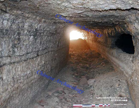
A gallery with the deposit of storage jars.
The Wadi el-Jarf site is south of the mouth of Wadi Araba, 24 km south of Zafarana, on the foothills of South Galala, near the Wadi Deir leading to the well-known Saint-Paul monastery. The site was first seen in 1823 by the British explorer Sir John Gardner Wilkinson, and then in the 1950s by Francois Bisset and Rene Chabot-Morisseau, French pilots of the Suez Canal. The place was rediscovered by our team in the late 2000s following information given by its previous visitors, and we started the excavations there in June 2011. This initial field campaign allowed for the identification of different components of the site and the sketching out of a thorough topographical plan. The site is developed over 6 km from east to west, from the first rocky foothills of the mountains of the eastern desert to the Red Sea coast. It consists of the following elements:
1. A system of storage galleries comparable to those recently uncovered on the other two currently known pharaonic Harbors on the Red Sea (Ayn Soukhna and Mersa Gawasis). This complex is substantially more developed than those of the other sites, counting some thirty galleries. Seventeen of them are arranged in radial fashion around a small rocky hillock, while nine others – and most likely many more buried in the sand – are dug into the side of a small wadi oriented north-south. On average, they are some twenty meters long, three meters wide and two meters high – but at times extend more than thirty meters. At the entry, the vestiges of an elaborate closure system are systematically present, with the gallery’s opening having often been made narrower by the placing of a slab on one side prior to its condemnation by large blocks in the axis of the slope.
2. Camps of the Old Kingdom are further east, in the last of the limestone hills overlooking the immense coastal plain bordering the Red Sea at this location. The most developed one contains several stone installations circumscribed by a long north-south wall controlling access to the complex, with a natural drain doing so to the east.
3. Halfway between the camps and the coast, at the heart of the coastal plain separating the last mountainous surge from the sea, a large rectangular dry stone structure has been discovered, covered in a great deal of sand (60 x 30m, internally divided into 13 long transverse spaces).
4. A final complex of installations is located on the coast itself. Here a L-shaped jetty is still visible during low tide, largely underwater except for the extremity of the east-west branch, which is anchored to the shore. This jetty begins on the shore and continues underwater to the east, with a length of almost 200 m. It then veers off southeast on a more irregular track for around 120 m. Its visible part reveals a rather regular assembly of large blocks and limestone stones, allowing for the protection of a vast artificial anchorage zone of over 2.5 ha. Submarine exploration carried out during low tide has confirmed the harbor function of this installation: more than 20 limestone boat anchors were discovered in situ, in sheltered position to the south of the jetty’s east-west branch. The discovery near the anchors of at least a dozen large jars identical to those found elsewhere on the site indicate that all of these installations are contemporaneous with one another.
Ultimately, it is clear that the series of installations of the Wadi el-Jarf are closely linked with the coastal site of El-Markha/Tell Ras Budran, on the other bank of the Gulf of Suez, directly across from the aforementioned jetty. At this location, a team from the University of Toronto has been excavating a circular fortified structure that visibly marks the landing point for expeditions leaving from Wadi el-Jarf, which is confirmed by the fact that the ceramics locally produced at the latter site represent an overwhelming proportion of what is found along the Sinai coast.
Since 2011, we have led five archaeological campaigns on the site – with a workforce of 70 Egyptian workers, and an international scientific team of 10-15 members. We made the choice to excavate the most characteristic spots of the place first: the caves complex, which is probably one of the main common feature of those pharaonic Harbors on the Red Sea, and the area of the big jetty, due to the uniqueness of this structure.
Harbor
The search was focused in 2013-2014 on an occupation zone located some 200 m from the coast. There, many traces of walls were visible on the surface before the excavation and a boat anchor was spotted on the surface. A systematic search conducted on an area of approximately 1000 m2 showed two successive occupations that can both be securely dated to the beginning of the 4th dynasty (c. 2600-2550 BC). The oldest is the development of two stone structures of great dimensions, measuring 30 m long by 8-12 meters. The two settlements were built parallel to each other along a north-south axis, back to the north to shelter the internal spaces of the prevailing winds and the risk of siltation. A deposit of 99 stone boat anchors was found at its original place in the empty space left between these two structures. Some of these anchors were still equipped with remains of ropes tied to them. A significant number of them also wear inscriptions in red ink giving the name of the boat to which they originally belonged. In 2015, we also excavated the landing part of the pier, which proved to be a very impressive structure. It was built on its northern part with limestone pebbles in successive slightly concave sections of about 5 m, whose angles are systematically fitted with larger and chained blocks – the inner part of it being constituted of smaller stones carefully compacted with a yellow clay.
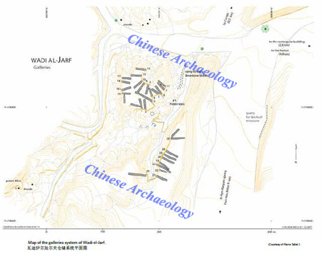
Map of the galleries system of Wadi el-Jarf.
The gallery complex
After five campaigns of excavations since 2011, 17 of the 30 storage galleries have been fully cleared. Three of them contained a practically undisturbed deposit of several dozens of large locally made storage jars, which probably served as water containers. Those jars were often inscribed with the name of the teams of workers to which they belonged. Other excavated galleries seem to have been used to store dismantled boats in between two expeditions on the Red Sea. Very little remains of the original deposits, which appear to have been fully removed in the antiquity – but we found hundreds of pieces of wood, fragments of oars, and sections of ropes that proves big boats were originally stored in those caves.
The systematic excavation of access ramps arranged in front of the storage galleries provide extensive information about the various phases of use of the site. All of the galleries seem to have been dug at the same time and the debris from this digging activity was used to level the natural slope and create a functional platform in front of the entrances. During the final phase of occupation of the site, the final closing of the galleries necessitated a major work operation. On this occasion, several large quadrangular blocks of limestone weighing several tons - a size worthy of the pyramid builders - were used to frame a kind of access ramp on both side of the entrance. Each gallery was then finally closed by one large limestone block placed in the axis of their entrances, which was dragged with ropes and pushed in position on a wooden slideway (reusing boat pieces) and a sliding fresh mud level, like a portcullis system. A majority of these limestone blocks show large control marks in red ink dating back to the reign of Khufu, which offer an accurate terminus to the implementation of this final closing system. Recognized among the various formulas, which refer to teams of workers, the most remarkable one was found regularly on different blocks and mentions one team whose name is formed on the birth name of the King: “the escorting team of <the boat whose name> is Khufu brings its two Uraei” – giving the idea that one of the boats originally stored in the galleries was probably equipped with royal symbols at its prow.
Discovery of papyrus from the reign of Khufu
The 2013 and following campaigns have led to an even more remarkable find. A huge amount of papyrus – hundreds of fragments - dating back to the reign of Khufu have been collected during the excavation of the galleries G1 and G2 of the site. This is to date the oldest papyrus archive ever found in Egypt. Some of them, the more fragmentary, were scattered almost to the surface. But most of them were still buried in a narrow space between two closing blocks of the gallery G1, where they had obviously been placed at the time this cave was closed for the last time. It is likely that this full archive had originally been stored there, the papyri having clearly been deposited as rolls at the bottom of this pit. After the campaigns of 2013, 2014 and 2015, nearly 800 fragments of varying sizes have been placed under 100 glass frames and handed to the Ministry of Antiquities of Egypt. A dozen of these documents is very well preserved and it is sometimes possible to restitute sheets of papyrus of about 1 m long.
Most of these papyri are well dated from the very end of Khufu's reign, and the date of the year after the 13th cattle count appears on one of the best-preserved examples. This means that we are dealing with Khufu’s regnal Year 27, the most recent year currently attested for his reign (the cattle count was held every second year). This information makes these documents the oldest inscribed papyri that have been ever discovered in Egypt. This is probably the archive of a team of sailors, and it mainly includes two categories of documents. First, there is a large number of accounts organized in tables, which correspond to daily or monthly deliveries of food from various sectors including the Nile Delta. This archive has considerably expanded the papyrus documentation known for the entire Old Kingdom and confirms that the operation and control of the Egyptian administration was already extremely structured and well-operational by the very beginning of the 4th Dynasty.
Another exceptional type of document can be added to these accounts, of which more than three hundred fragments of varying sizes (some over 50 cm in length) have been discovered: logbooks of daily activities, conducted by a team led by an official, the inspector Merer, that were recorded over several months. The most surprising is that those documents, for what is preserved of them, do not report the activity of this group on the Wadi el-Jarf site. It records a period over the course of several months – in the form of a timetable with two columns per day – with many operations related to the construction of the Great Pyramid of Khufu at Giza and the work at the limestone quarries on the opposite bank of the Nile. On a regular basis, there are also descriptions concerning the transportation, on the Nile and connected canals, of stone blocks, which had been extracted from the northern and southern quarries of Tura. These blocks were delivered within two or three days at the pyramid construction site, called the ‘Horizon of Khufu’, and were probably used for the external casing made of fine limestone of the Great Pyramid. Merer's journal also mentions his passage at an important logistic and administrative center, ‘Ro-She Khufu’ - which seems to have functioned as a stopping point near by the Giza plateau. It is especially specified that this site is under the authority of a high rank official, Ankhhaef, half-brother of Khufu, who was his vizier and “chief for all the works of the king” at the end of the reign. Other logs found in the same archive also give information about others missions accomplished by the same team of sailors during the same year, notably the building of a Harbor on the Mediterranean sea coast.
The surprising presence of these documents on the Red Sea site at Wadi el-Jarf is most likely explained by the fact that the same specialized teams that worked on the construction of the royal tomb were also responsible for some operations at this port facility. In this context, the installations at Wadi el-Jarf should probably be considered as a distant dependency of the project of the Great Pyramid, in order to obtain, from the mines of the southern Sinai, the large amount of copper that was needed for the tools used at Giza.
Conclusion
After five excavation campaigns, the knowledge of the Wadi el-Jarf site has made great progress, all data focusing on both the complexity of the organization of expeditions, the massive character of the Egyptian installation and the relative shortness of its use - most of the material points to the reign of Khufu, whose name appears in dipinti on jars, control marks, sealings and papyrus. The written evidence for this early period of the Egyptian history – hitherto very scarce - has been more than doubled by the discovery of the papyrus on the site, and their study will allow, for the first time, an inner knowledge of the pharaonic administrative system of this period, and of some of the major projects of the Egyptian monarchy at this time.
Pierre Tallet
Born in Bordeaux (France) in 1966, Pierre Tallet is a former member of the Ecole Normale Supérieure of Paris. He studied Egyptology at the University of Paris-Sorbonne, where he earned a PhD about wine in ancient Egypt in 1998. A longtime member of the French Institute of Oriental Archeology in Cairo (IFAO), he took part to several archaeological missions in Egypt: in the oases of the Libyan desert (Dakhla, Bahareya), in the Sinai Peninsula and in the Luxor area (Karnak temple, Deir el-Medina village, Gurna necropolis). He is currently associate professor in Egyptology at the University of Paris-Sorbonne, and the director of the research team “Pharaonic Worlds”, part of the UMR 8167 of the French CNRS. Since 2011, he is heading the archaeological mission of the Wadi el-Jarf, on the western coast of the Gulf of Suez, where the oldest currently known Harbor in the world has been identified, and where the most ancient papyri, dated to the reign of Khufu, were recently found. The excavation of this site is conducted with the strong involvement of Grégory Marouard, associate member of the Oriental Institute of Chicago, and Damien Laisney, member of the Maison de l’Orient et de la Méditerranée (Lyon).
(Pierre Tallet Paris-Sorbonne University)
(Source: Research Center for World Archaeology, Shanghai Academy)