

In Search of the Pyramid Settlements: Archaeology of Everyday Life at Giza
For twenty-five years Ancient Egypt Research Associates AERA) teams have been excavating settlements where the pyramid builders worked and lived at the southeastern base of the Giza Plateau, finding their structures of everyday life: homes, workshops, cattle corrals, bakeries and harbors. We cannot understand a civilization like that of the pyramid builders unless we know the elementary structures and local rules of everyday life that generate its transformations.
Before AERA’s excavations, two centuries of archaeology already established beyond doubt that Egyptians of the Old Kingdom, 4th dynasty (c. 2575-2472 BCE), built the largest of Egypt’s pyramids at Dahshur and Meidum for the pharaoh Sneferu and on the Giza Plateau for the rulers Khufu, Khafre and Menkaure. In the temples attached to the pyramids, Egyptologists found sublime statues of the Giza kings inscribed with their names. When the great expeditions of the early 20th Century cleared the cemeteries flanking the pyramids where family members buried high officials, they found statues of courtiers and chapel walls decorated with relief-carved and painted scenes of their ideal life. Names and titles provide an index to the royal family and government offices of that time. The great cedar ships of Khufu, the gilded furniture of his queen mother Hetepheres, the Great Sphinx, and the massive stonework of the tombs and temples and all convey the technical sophistication and engineering of these people who commanded the society of the pyramids.
But excavation of the royal cemeteries revealed little about the broad masses of people who did most of the actual work on the pyramids. How were they recruited, mobilized, organized, and accommodated and fed at the construction site? As AERA Board member Ed Fries, co-inventor of Microsoft’s Excel, put it, “The ancient Egyptians were struggling with the same thing that programmers have been struggling with for over 40 years: how to deal with increasing levels of complexity as projects get large”.
Complexity in the Third Millennium BCE took form in the first cities in the Near East, but Egyptologists once debated whether Egypt was a “civilization without cities.” At the same time, their estimates for the numbers of people required for building the Great Pyramid of Khufu ranged into the tens of thousands – equal to the estimates for the populations of earliest cities that emerged in the Indus Valley, Mesopotamia and North Syria. The AERA team asked: Where at Giza were all these people housed? Where should we find their settlement? Would it not comprise, de facto, a proto-city? What would it tell us about the lives of the pyramid builders, how they were organized? To truly understand the pyramids we had to turn our back to them, and scan the surroundings. We needed to look at the pyramids in their context as huge architectural landscape projects.

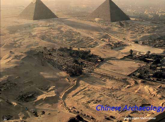
Survey and geo-archaeological analysis directed us to the southeastern base of the Giza Plateau, where the middle Eocene limestone of the Moqqatam Formation – the pyramids plateau proper - slips under the low desert and its interface with the Nile floodplain. With the Giza Plateau Mapping Project from 1984-1987 we mapped the clues left by ‘human disturbance on a geological scale’: the shape of the plateau, access routes and the locations of quarries, the ‘holes’ corresponding to the ‘piles’ of the pyramids. The gigantic ramp had to run in between. Just beyond the quarries, a broad wadi between the pyramid plateau and the Upper Eocene Maadi Formation, rising on the south, provided access for materials and people from outside Giza.
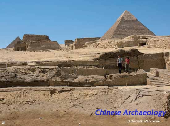
We then expected settlement and infrastructure t the southeast, beyond the quarries and wadi access. Just here, projecting from the southern side of the wadi about 400 meters south of the Great Sphinx, the colossal Wall of the Crow, 200 m long, 10 m wide and 10 m tall, lay half-buried. Built like the pyramids of huge stone blocks, this wall signaled that settlement of major importance lay to the south, buried under a thick overburden of sand and modern dumping.
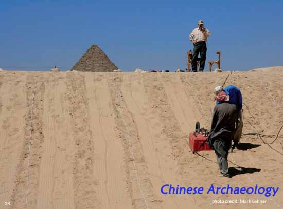
AERA teams began to excavate in 1988-89. In 1999 our work took on the urgency of salvage archaeology, as modern urban expansion, tourist facilities, and a soccer field rapidly encroached. Heavy machines trenched the site, cutting through mudbrick walls and settlement layers. Through twenty-five years of clearing, mapping, and targeted excavation, we revealed and salvaged 7 hectares of settlement where Egyptians lived and worked while they built the pyramids of Khafre and Menkaure, with a lower horizon possibly dating back to Khufu.
We call the site HeG, for Heit el-Ghurab (HeG in short), Arabic for “Wall of the Crow,” because this landmark forms the northwest boundary of the settlement. In the central feature, the Gallery Complex, state planners assembled large modular units, “galleries,” with a width to length ratio ration of 7:1, into four great blocks separated by three, east-west cross streets, 5.20 m (10 royal cubits) wide. We hypothesize the galleries served as barracks for members of teams that slept in the long, empty front colonnades. Overseers of these teams stayed in small house-like room complexes in the southern ends of Gallery Sets II and III, where cooking, roasting or baking in the rear chambers – food preparation for each team - is evidenced by much ash and scorched walls.
Other structures for food processing and storage surround the Gallery Complex on the east, west and south, including modular, open-air bakeries with a production capacity far beyond the needs of an individual household. At the southeastern corner of the settlement a large enclosure, which we call for convenience, the “Royal Administration Building” (RAB), features a sunken court of large, round silos, 2.5 m diameter, probably for grain storage. On the far eastern limit of our exposure, the Eastern Town consists of small courtyards and chambers that reflect the self-organization or “organic” order characteristic of villages. In the Western Town, large “elite” houses yielded thousands of sealings, some of which bore the highest-ranking scribal titles of the reigns of Khafre and Menkaure. These official residences served as administrative centers and scribal workshops. On the far southwest of the site, we found in 2011 a cattle corral and possible abattoir.
AERA’s teams are truly international, and our approach is interdisciplinary. For 25 years (1988-2012), as AERA team members carried out these targeted, stratigraphic excavations in the HeG, they systematically retrieved all classes of material culture – including animal bone, carbonized plant remains, chipped stone (lithics) and clay sealings, resulting in one of the largest material culture data sets from any archaeological excavation in Egypt. We are thus able to carry our archaeology to the micro-scale, with analysis of material culture in our field lab. Among our findings: ample evidence of state provisioning, with high consumption of protein in the form of cattle, sheep, goat and fish, and carbohydrates, mostly from bread.
If we take the Gallery Complex as barracks for common workers rotating in and out of the obligatory labor duty known from ancient Egyptian texts, we see in the provisioning better nourishment than we might expect from popular notions of compulsory labor. Geographic Information Systems (GIS) analysis allows us to hone the picture, with distribution patterns of the hundreds of thousands of iterations of various classes of material culture. We can see, for example, the best meat bone concentrates along with sealings bearing high-ranking administrative titles in the Western Town and certain guardhouses.
Analysis of charcoal and pottery broadens the picture onto an international scale. We find that wood like Cedar, Pine, and Oak, imported from Lebanon and the Levant must have been ubiquitous enough to burn. The presence of olive wood is Egypt’s oldest attestation of olive, and probably relates to imported Combed Ware pottery, very possibly imported as containers of choice olive oil from the Levant. These costly imports, revealed only under the microscope, raise our awareness that Giza must have been the major Nile shipping port of its time, receiving goods from the eastern Mediterranean port of Byblos in the north, to Aswan and Nubia in the far south. We have to consider the greater HeG as an entrepôt, and the Gallery Complex as possible storage and barracks for elite troops chosen for expeditions, both shipping and building, or possibly a royal guard force.

Beginning in 2005 AERA expanded work across the wadi to reexamine the Menkaure Valley Temple and Khentkawes Town (attached to the funerary monument of the queen whole may have ruled in her own right at the end of the 4th dynasty). Between the HeG and these settlements, excavated by George Reisner and Selim Hassan between 1908 and 1932, AERA now studies the whole range of settlement from workers’ camps to the formal pyramid towns of priests and officials known from ancient hieroglyphic royal decrees and titles etched in the tomb chapels of their administrators. Between 2007 and 2012, AERA teams discovered a harbor basin east of the Khentkawes Town, probably one part of the broader port and water transport infrastructure that existed north of the Wall of the Crow, and east of the Sphinx, now mostly sealed by modern city.
By studying the ancient settlements at Giza we have our finger on the pulse of urbanism during a critical threshold – the first great efflorescence of Egyptian civilization in the Old Kingdom, a threshold that bears significant implications for where we find ourselves in civilization today, now global in the Third Millennium of the common era.
Mark Lehner (Ancient Egypt Research Associates)
Biographical Sketch
Dr. Mark Lehner is Director and President of Ancient Egypt Research Associates, Inc. (AERA), an American nonprofit organization, an NGO registered with the Egyptian government as AERA-Egypt. Dr. Lehner has carried out archaeological research in Egypt for over thirty years. He has mapped and excavated at the Great Sphinx and Pyramids in Giza. AERA, Inc. sponsors the Giza Plateau Mapping Project (GPMP), which conducts annual excavations of Old Kingdom settlements near the Sphinx and Pyramids with an interdisciplinary and international team of archaeologists, geochronologists, botanists, and faunal specialists. From 1990-1995 Lehner was Assistant Professor of Egyptian Archaeology at the University of Chicago. He is now a Research Associate at the Oriental Institute of the University of Chicago.
Lehner was born, raised, and began his college education in North Dakota. He went to Cairo in 1973 as a Year Abroad Student at the American University in Cairo where he received his B.A. in Anthropology. He lived in Egypt in for 13 years, working for American, Egyptian, British, French, and German archaeological projects. From 1979 until 1983 he was the Field Director and then Director of the Sphinx Project sponsored by the American Research Center in Egypt. In 1984 he began the Giza Plateau Mapping Project (GPMP), sponsored by ARCE and Yale University where Lehner received his PhD in Egyptology in 1990.
In 1988 the GPMP began to excavate in search of the settlement and infrastructure that supported the pyramid work force. The team has discovered a workers’ city that includes workshops, storage buildings, bakeries and a large royal administrative center from the time of the pyramids (ca 2,500 B.C.). Major support for AERA’s research excavations GPMP has been provided by the David H. Koch Foundation, the Ann and Robert H. Lurie Foundation, the Charles and Lisa Simonyi Fund for Arts and Sciences, Peter Norton and the Isambard Kingdom Brunel Society, the Ted Waitt Family Foundation, Mr. and Mrs Lee M. Bass and the Myhrvold Family Charitable Foundation.
Since 2005 AERA has conducted archaeological feld schools to train young Egyptian archaeologists working for the Egyptian Ministry of Antiquities at Giza, Luxor and Memphis on behalf of the American Research Center in Egypt (ARCE) funded by USAID, the Charles Simonyi Fund for Arts and Sciences, and the Bill and Melinda Gates Foundation.
Lehner has appeared on television in National Geographic's Explorer program, and on the WGBH NOVA series, Secrets of Lost Empires series on ancient technology, including This Old Pyramid and Obelisk. In 2011 Lehner appeared in NOVA’s Riddles of the Sphinx. He is author of The Complete Pyramids published in 1997 by Thames and Hudson. His work has appeared in articles in National Geographic, Smithsonian, Discover and Archaeology.