

2019 SAF Discovery Awards|Globalisation along the early Maritime Silk Road: A view towards a systemic and plural history from the Isthmus of Kra
Introduction
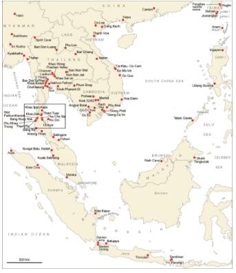
Taking Braudel as a frame of reference and inspired by “Global studies” and “Connected History” works, the research summarized here concerns the long-lasting cultural exchange process between the Bay of Bengal and the South China Sea, an ancient globalization traditionally called “Indianisation”, also corresponding to the eastern part of the “Maritime Silk Road”. The Thai-Malay peninsula is a long stretch of land between these two maritime basins and the Isthmus of Kra is located in its upper and narrowest part. Running along the peninsula, the chain of Tenasserim (mountains up to 2000m height in the northern part of the peninsula) is punctuated by valleys whose rivers flow along its slope, some of which constitute passages called “transpeninsular routes”. Despite the presence of historical ports on both coasts, historians did not consider these tracks traversing different environments (marine, estuarine, plains, and forests) and requiring various modes of transport as serious candidates as trade routes.
Research was conducted in the Isthmus of Kra by the French-Thai Archaeological Mission in peninsular Thailand, a collaboration with Silpakorn University (Bangkok) represented by Praon Silapanth and prof. Rasmi Shoocongdej from 2005. From 2017, the mission evolved into the French Archaeological Mission in peninsular Thailand-Myanmar with the Department of Archaeology and the university of Mandalay as new partners respectively represented by U Maung San Win (Dawei Branch) and Kalayar Myet Myet Htwe.
The research focuses on the inception and process of cross-cultural exchange during the first millennium BCE and until the early centuries CE. The Archaeological Mission’s team implements the Technological Approach (a field of Anthropology of Technics) of industries to characterise each group’s socio-technological system. The Mission also develops a regional archaeology by excavating and surveying different types of sites (caves, open-air settlements, relay stations) from different environments (coastal, mangrove, offshore islands and forested inland).
The objectives are to study the spatial distribution of the different technological groups, to generate a cultural sequence of the social groups in the peninsula, and to study their organisation and local and regional interactions. By doing so, we aim at studying the co-evolution of the different groups present in the peninsula (local and exogenous) and their environment in relation to the region’s insertion into inter-regional exchange networks. Additionally, the aim is also to determine how each of these groups contributed to the regional historical trajectory.
Results – Synthesis on the socio-economic organisation during the last centuries BCE
The mission excavated and surveyed 36 sites unraveling a sequence of a complex network of hierarchic and specialised sites involving various social groups present in the peninsula. This complex network formed part of incipient city-states acting as regional cultural cradles. From the late 5th-early 4th c. BCE regional ports-of-trade such as Khao Sam Kaeo develop out of the still poorly known early first millennium BCE early regional networks. From the 3rd c. to the 1st c. BCE, activity within exchange networks clearly increases and local and exogenous groups belonging to different environments appear economically and culturally better defined and area all working in concert and contributing to elaborate a pan-regional culture or what one may want to call global culture.
1. The emergence of complex port-settlements and their immediate hinterland- 4th c. BCE
In the course of the late 5th c. or the early 4th c. BCE, local port-settlements acting as regional economic and cultural centres emerged, such as at Khao Sam Kaeo and Khao Sek on the eastern coast and Phu Khao Thong on the western coast. They already display the development of complex urban and political models and of an elaborate economic organisation. They not only concentrate large ranges of imports from South Asia and the eastern part of the South China Sea but also had active workshops. Those manufactured products of a pan-regional style I called “Late Prehistorical South China Sea style” that combined foreign raw materials and skilled techniques (often Indian) sometimes under the aegis of foreign artisans. These goods were redistributed at local and regional levels from Thailand to the Philippines. This style attests to the already well-established maritime orientation of lowland groups towards both the Bay of Bengal and more strongly (i.e. currently supported by more archaeological evidence) towards the South China Sea by the mid-first millennium BCE.
A major centre for their production is Khao Sam Kaeo (investigated 2005 -2009), an urban complex dated to the late fifth to second/first centuries BCE. Commanding a transpeninsular trade route, it was located 8km from the eastern coast. It hosted foreign communities who lived within urban quarters demarcated by embankments. Its occupation stricto sensu extended over 35ha within simple and twin parallel earth walls that were probably surmounted by wooden palisades. A hydraulic system created a mooring place (valley 1), and to retain water, possibly for agricultural purposes (valley 2). The network of habitations on piles and terraces was dense and characterized by accumulations of monumental and domestic terraces and drains.
Two clearly defined zones emerged from the spatial analysis: a southern area corresponding to Hills 1 and 2, the initial core used by local populations and a few foreign artisans characterised by the early “Late Prehistoric South China Sea style” type of material culture. From the early 4th c. BCE, materials were locally worked using imported raw materials and exogenous styles or techniques. Further north, on Hills 3 and 4 corresponding to a later expansion of the settlement (see below our Period 2), there were communities of foreign merchants and artisans. The latter were indicated by the presence of Indian Fine Wares, crucibles for high-tin bronze metallurgy, and northern Vietnam and Han Chinese material. More finished objects were imported whilst others were kept being locally produced with exogenous technologies such as high-tin bronze bowls. These locally-made artefacts belong to a later phase of “Late Prehistoric South China Sea style” that then includes more South Asian-adapted products as illustrated by ornaments and ceramics.
Khao Sam Kaeo is currently the earliest cosmopolitan complex polity of Southeast Asia. It is a serious candidate for an incipient port-city. This is supported its monumental constructions, its enclosing walls, moats and water systems that were built, transformed and maintained over centuries, thus the produce of a level of authority able to control considerable labour for their erection and a coherent political agenda implemented over several generations for their regular maintenance. Its economic organisation was also complex and sustained by an agricultural production supporting the various activities. In addition to monumental evidence, socio-political complexity is indicated by the internal organization of the site as characterized by socio-professional zones hosting different social groups and activities. Craft activities depended on far-reaching supply and distribution networks (the glass and hard stone industries are a good examples) and involve foreign specialists.
The sources of inspiration for the elaboration of urban spaces in Southeast Asia suggests a combination of regional developments with the “moated-settlement tradition” found in many parts of Mainland Southeast Asia and of external inputs. Regarding Khao Sam Kaeo, besides regional models, the walled cities of South Asia dating from the ‘second urbanisation’ of the early to mid-first millennium BCE may have been a source of particular inspiration considering similarities in morphology, location, size and rampart system.
The port-settlement of Khao Sek located 80km south of Khao Sam Kaeo appears built on a similar model as Khao Sam Kaeo, though smaller and less complex, not showing signs of surrounding walls and cosmopolitanism. However, Khao Sek and Khao Sam Kaeo technical systems are identical, characterised by the same highly skilled hybrid craft industries evolving simultaneously. These sites and technological system comparisons draw a complex political structure taking the form of a confederation of hierarchically specialised and complementary city-states. Khao Sek controlled the exit of another transpeninsular route connecting with sites in the Kraburi area. There is no evidence of foreign communities at the sites, providing further arguments that Khao Sam Kaeo acted as the international market place. It seems likely that this confederation was established over several river basins, but also involved a larger hinterland of allied port-settlements perhaps reaching neighbouring sea basins. This political structure would show some parallels with Malay port-cities organized on a hybrid model of a hierarchical upstream-downstream and “mandala” type described by P.-Y. Manguin for Srivijaya. In this context, Khao Sek would be part of the periphery of Khao Sam Kaeo.
The populations living in the vicinity have until now only been visible through funerary deposits consisting of stone and glass jewellery and complex pots found in neighbouring caves coming from the regional industrial ports. Exchange between these regional ports themselves and their immediate hinterland may also have been based on the exchange of agricultural products. Rice and millet constituted the agricultural base at Khao Sam Kaeo and potentially at Khao Sek too (Castillo, 2017). Other indirect evidence for links with the hinterland lies in local tin whose exploitation is demonstrated by analysis of bronze craft production.
2. Increased exchanges based on a complex cooperation between many groups culturally and economically better defined
From the 3rd c. to the 1st c. BCE or more, exchanges increase and get organised with specialised sites emerging (such as relay/transhipment stations). Whilst local groups appear economically and culturally better defined, many more groups were then present in the peninsula, some settling in port-settlements, others at river mouths and on neighbouring islands that we interpret as early sea nomads. During this second period, culturally distinct groups belonging to the different environments; island, in ports, at river mouths and inland were connected and working in concert.
During this later period, more port-settlements are identified: Phu Khao Thong-Ban Kluay Nok complex on the western coast in Thailand, Maliwan and possibly Aw Gyi in southern Myanmar. Many more foreign groups and imports are found there, some indicating links with the Western world. This is probably the period when Khao Sam Kaeo extends further north and new surrounding walls are built around the new compounds. Port-settlements concentrate larger ranges of materials indicating the presence of many more social groups. In the latter are now found imports from Han China and from South Asia, as well as more material from the South China Sea, the Philippines and Taiwan.
During this period, a series of inland sites emerged along main and secondary transpeninsular routes. There are caves located in the Tenasserim central chain that were used as temporary camps and for funerary practices yielding ornaments in stone and glass made or imported from regional port-settlements. There also are open-air transhipment and collecting sites often localised at rivers’ tributaries. These are at roughly regular intervals along these river systems. They yield archaeological remains related to long-distance networks such as Dong Son drums from northern Vietnam or southern China, glass beads, and exogenous ceramic (Indian Fine Ware). Those include Wat Pathumtaram (Ranong), Ban Na Hyan and Pangwan along the River Langsuan (Chumphon) and Tham Nam Lot along the smaller River Sawi (Chumphon). These inland sites constitute crucial evidence that was missing before to support the use of transpeninsular routes.
From this period, exogenous groups with closer connections with the South China Sea and the Philippines in particular are present in the peninsula. Some of those groups that we interpret as early sea nomads are active at river mouths to command the upstream-downstream trade. Others settled in ports. They became prominent at these strategic locations being intermediary between ports-settlement and the upstream-downstream/transpeninsular networks. Their material culture attests to their involvement in both inter-regional networks and in local upstream-downstream exchange networks. These groups using coastal and offshore caves were in recurrent contact with the Philippines as revealed by comparative studies of the Sa Huynh-Kalanay-related pottery from the Thai-Malay Peninsula and the Philippines.
Conclusion
The model I propose envisions cultural processes through the lenses of “co-constructions” within networks of confederated port-cities and their hinterland composed of variously organized groups for a time allied in a larger connected regional space embracing the two sea basins. This structure can explain the spread of a pan-regional style whose hybrid nature was crafted by the various groups that were part of this extended political structure. The emergence of this centralised structure also crystallized cultural differentiation and economic specialization. Amongst the groups concerned, some usually referred to as marginal groups, the earliest sea nomads, emerge as key actors as economic and cultural intermediares within this network. This model offers a more balanced representation of exchanges and overall globalization processes beyond cores and peripheries. It reveals dynamic networks and configurations in which an active chain of intermediaries with fluctuating allegiances are involved and play an active economic and cultural role.
Biographical Sketch
Dr Bérénice Bellina, archaeologist of South and Southeast Asia, is Senior Researcher at the National Centre for Scientific Research. Her research focuses on exchange and cultural transfer processes on the Maritime Silk Road and more especially between South and Southeast Asia. She uses the technological analysis of industries as a means to comprehend sociopolitical processes and to reconstruct the impact of long-distance exchange and local resource acquisition on ethnicity and identity construction. In 2005, she created the Thai-French Archaeological Mission in Upper Thai-Malay Peninsula with Silpakorn University (Bangkok). And since 2017, she directs the Myanmar-French Archaeological Mission in Peninsular Thailand-Myanmar with the Department of Archaeology (Ministry of Religious Affairs and Culture of Myanmar). This programme engages students and researchers from around the world, with the aim of developing a systemic approach of regional exchanges, investigating the co-evolution of different populations and ecosystems in relation to long-distance exchanges from the early/mid first millennium BC to the late first millennium AD. As a consequence, she works at elaborating an archaeology of what have been termed “marginal groups” such as sea nomads, to investigate their history in a long-durée perspective. She also has developed an interest in heritage, with a special focus on present-day representations and uses of the past, and in particular of Maritime Silk Road remains in Southeast Asia. This interest has resulted in local communities participating in patrimonialisation projects. Her research combines archaeology, archaeological science, connected history, museology, social anthropology and technology studies.