

2019 SAF Discovery Awards|Fort San Juan and the Limits of Empire: Colonial Encounters at the Berry Site
INTRODUCTION
What strikes you, the first time you walk across the Berry site, is how unremarkable it is. It occupies the eastern edge of a field like so many others across the western Piedmont of North Carolina, a wide expanse of rich floodplain that is hemmed in by the foothills of the Appalachian Mountains. Upper Creek—a tributary of the upper Catawba River as unremarkable in name and appearance as Berry itself—borders the site on two sides. Two other sides are edged by ornamental tree farms, with a corn field in between. The fields on the opposite bank of Upper Creek are also planted in trees and shrubs. Today, only the lower end of the site is annually plowed for small garden plots of corn, squash, beans, cucumbers, tomatoes, melons, potatoes, and even broccoli. The rest of the site lies fallow. There are no great mounds to climb at the Berry site, no wide plazas to cross. Compared with some of the more photogenic sites in North America, you might justifiably walk onto Berry and think to yourself, there is nothing to see here.
But beneath the surface, out of reach of the plows, the story we are recovering at the Berry site is, indeed, remarkable. Berry is the location of the Native American town of Joara, and it was here—on December 27, 1566, the feast day of St. John the Evangelist—that the Spanish captain Juan Pardo established Fort San Juan and its adjoining colony of Cuenca, named after his own hometown in the province of Castile. Fort San Juan was the very first European settlement in the interior of what is now the United States, and was likewise one of the first places in North America to experience the birth of globalization. Pardo garrisoned his fort with 30 men, and for much of the 18 months that followed they enjoyed good relations with their Native hosts, who supplied the Spaniards with most of their daily food and provisions. Yet relations between the people of Joara and the men of Fort San Juan had deteriorated badly by the spring of 1568, when the Indians here and at the six other towns across the Carolinas and eastern Tennessee where Pardo built forts rose up and destroyed the Spanish garrisons. Never again would Spain attempt to settle the interior of La Florida, a territory that once included most of the American Southeast, creating a vacuum that English settlers would exploit during the centuries to come.
JOARA AND FORT SAN JUAN
During the first half of the sixteenth century, Spanish explorers failed in several efforts to colonize what is now the southeastern United States. Finally, in 1565-1566, Pedro Menéndez de Avilés successfully founded two settlements on the south Atlantic Coast: San Agustín, founded September 1565 in Florida, and Santa Elena, founded April 1566 on present Parris Island, South Carolina. The latter, Santa Elena, was to be the center of Menéndez’ colonial aspirations. When Philip II learned of this success, he ordered reinforcements for the new colony. In July 1566, Captain Juan Pardo arrived at Santa Elena with a company of 250 soldiers and began to fortify the settlement. As the Santa Elena colony was ill-prepared to feed this large contingent of men for very long, however, Menéndez ordered Pardo to prepare half of his army for an expedition into the interior that lay behind the Atlantic coast. Pardo’s task was to explore the region, to claim the land for Spain while pacifying local Indians, and to find an overland route from Santa Elena to the silver mines in northern Mexico. Pardo left with 125 men on December 1, 1566.

Later that month, after crossing the Carolina Piedmont along the Wateree and Catawba rivers, Pardo and his men arrived at Joara, a large Native town situated in the Catawba Valley near the eastern edge of the Appalachian Mountains. Joara’s chief, referred to in the accounts as Joara Mico [Mico was a native term for regional chief], held authority over a number of neighboring towns along the upper Catawba River and its tributaries. Pardo renamed this town Cuenca, after his own native city in Spain. At Joara, he built a fort, San Juan, which he garrisoned with thirty men. Although earlier expeditions into the interior had constructed seasonal encampments or had temporarily occupied native towns, Pardo explicitly built Fort San Juan to expand the Santa Elena colony into the northern frontiers of La Florida. In so doing, he established the earliest European settlement in the interior of what is now the United States. Pardo would go on to build five other outposts, but Fort San Juan was to be the center of his imperial designs.
Over most of the eighteen months that Spanish soldiers lived at Joara, amicable relations existed between the people of this town and their European guests–on at least two occasions, for example, the Spaniards accompanied native warriors in attacks on hostile native chiefs across the Appalachians in Tennessee and Virginia. Also, when Pardo was preparing to leave the fort during his second expedition, he commanded its ensign, Alberto Escudero de Villamar, to “judge and have a care of the conservation of the friendship of the caciques and Indians of all the land.” Yet in the months that followed Pardo’s departure in November 1567, relations between Fort San Juan and the people of Joara took a calamitous turn for the worse. By May 1568, news reached Santa Elena that Indians had attacked all of Pardo’s forts, including Fort San Juan, and that all were destroyed. Several factors may have played a role in this aggressive action, but two stand out: the soldiers’ demands for food and their improprieties with native women. In the end, 130 soldiers and all of Pardo’s forts were lost, and with them Spain’s last attempt to colonize these northern frontiers of La Florida. Indeed, it was more than a century before other Europeans are known to have penetrated this far into the southern Appalachians.
ARCHAEOLOGY AT THE BERRY SITE
Archaeological and historical evidence indicate that the Berry site (31BK22) is the location of Joara and Fort San Juan. Berry is situated along Upper Creek, a tributary of the upper Catawba River, in what is now Burke County, North Carolina. The site covers about 4.5 ha and is located along the eastern margin of a 75 ha alluvial bottomland at the junction of Upper and Irish creeks. Archaeological evidence indicates that Berry was one of the largest late prehistoric sites in the upper Catawba Valley. The site was first described in Cyrus Thomas’ 1894 report on mound explorations by the Smithsonian’s Bureau of Ethnology. The mound and the surrounding site were both regularly plowed, and sometime before about 1950 the mound itself was bulldozed to provide fill for a low-lying area that was subject to erosion. Our research extends over 22 field seasons or more than 120 weeks of excavation and archaeological survey.
In the sixteenth century, the Berry site (i.e., Joara) sat at the northeastern edge of the Mississippian cultural world and at the northwestern edge of Spain’s colonial frontier. Berry was the political center of a Mississippian chiefdom, one of many similar polities in the Midcontinent and Southeast from circa A.D. 1000-1600. Systematic surveys north and south of Berry have identified 26 sites with Mississippian pottery, and many of these were probably contemporaneous with Berry. We suggest that these nearby archaeological sites are the core of Berry’s polity, and we refer to this period of Native American occupation along the upper Catawba and Yadkin rivers as the Burke phase (A.D. 1400-1600). Our fieldwork at the Berry site has included systematic surface collection and gradiometer survey over most of the 5 ha site. Excavations total more than 1750 m² and concentrate on the 1.5 ha area where we have recovered a substantial assemblage of Spanish ceramics, hardware, and military items in association with both a compound of five burned buildings—which we identify as Cuenca and refer to as the Spanish Compound—and a fortification that constitutes the remains of Fort San Juan. Our research in these two contexts is offering unique insights into the archaeology of empire and colonialism across the Atlantic frontier.
THE SPANISH COMPOUND
The Spanish compound contains five large, set pole structures, four of which were built in semisubterranean basins and all of which were burned. To date we have investigated two of these buildings, Structures 1 and 5, excavation and analysis of which provide much of the data for our understanding of construction practices. Structure 1, the larger of the two, measured 7.5 m on a side (about 56 m²) and was among the four structures built in basins. Such basins were typical of Late Mississippian architecture throughout the South Appalachians, and indeed most of Structure 1 seemed typical of indigenous-style architecture in the region. It contained a central hearth, four large and deeply placed interior supports, and a well-defined entry with exterior trenches on a corner of the structure. Structure 5, measuring 49 m², was less typical of native architecture. While its central hearth was similar to that of Structure 1, it was not constructed in a basin, its entryway could not be identified, and its four central posts were placed in very shallow postholes, such that they that offered insufficient support for the structure’s roof–two additional interior posts were later added to stabilize the structure. Remarkably preserved organic samples from both buildings provide clear evidence both of metal tool use and European-style carpentry practices in wood harvesting, preparation, and construction. These include sawn timbers and a sawn chestnut plank from Structure 1 and wood slats from Structure 5, as well as spike or nail holes in samples from both buildings. Both buildings, along with the three that remain unexcavated, were burned to the ground at the same time, and there is no evidence that any was ever rebuilt.
Since 1986 we have identified more than two hundred features at the Berry site, of which we have excavated more than sixty. Most of the features we have identified and excavated are inside the Spanish compound. Given space constraints, our goal here is not to describe all excavated features, but rather to focus on the sample of features containing European artifacts or copper fragments that probably derive from non-aboriginal sources. To date, we have excavated 16 such features inside limits of the compound, which we have subdivided into two distinct clusters we refer to as the central features and the western features. Most of these probably began as daub processing pits during the process of house construction, after which they were filled with domestic trash. Others represent midden deposits near Structure 5 that also contain refuse.
Based on field and laboratory data, we have identified two phases of primary construction activity in the Spanish compound. In the first phase, three structures—1, 3, and 4—were built in a slightly curving arc near the northern edge of the site. We believe that the beginning of this first phase coincides with Pardo’s arrival at Joara in late December 1566, and data recovered from Structure 1, in particular the blending of distinct native and European carpentry and construction practices, suggests that this early period of the fort’s occupation was characterized by cooperative relations between the soldiers and their indigenous hosts. Indeed, when Pardo returned to Joara during his second expedition in September 1567, having left 30 men there the winter before, notary Juan de la Bandera recorded that “he found built a new house of wood with a large elevated room full of maize, which the cacique of the village…had built by the command of the captain for the service of His Majesty.” Feature 76, a circular hearth 66 cm in diameter and about 10 cm deep, was situated near the eastern edge of the central features and may have served as an open-air kitchen during the early phase of the compound’s use.
During the second phase of occupation, Structures 2 and 5 were built together along the same axis 15 to 20 m west of the first phase structures. Each of the two new structures intrudes into the central pit features, establishing the temporal priority of the latter. We may say little more about Structure 2, since as yet we have only exposed its southern corner and a portion of its eastern wall. Augur testing conducted in 1997, however, when the structures were all first discovered, indicates that this building has the same shape and size as the other semisubterranean structures in the compound. Moreover, these auger tests revealed that deposits in Structure 2 are similar in depth to those of Structures 1, 3, and 4; that is, Structure 2 seems to have been built in a basin of about the same depth as these others. Structure 5, then, is an anomaly, and we suggest that it was used as a formal cocina or kitchen during the compound’s second phase, replacing the open-air kitchen associated with Feature 76. Alone among the five structures in the Spanish compound, but like kitchens at other Spanish colonial sites, Structure 5 was adjacent both to refuse disposal pits and a large sheet midden, the only such deposit identified in the compound area.
FORT SAN JUAN
Our extensive work in the compound area has informed the domestic side of this colonial encounter. It was here that the soldiers of Fort San Juan would have passed much of their time. It was where they slept, ate their meals, developed personal relationships with one another and with the men and women of Joara, and where they followed the habitual and routine practices of daily life. What remained elusive, in all of our previous years of archaeological fieldwork, was evidence of the fortification itself—where was Fort San Juan?
At other early colonial sites, such living areas were often spatially distinct from defensive works. That is, separation was maintained between the domestic spaces of the colonial encounter and its public/defensive zones. In 1588, John Smith reported finding Ralph Lane’s settlement on Roanoke Island some three years after its abandonment. Its fort, he wrote, had “sundry necessary and decent dwelling houses made by his men about it the yeere before.” Depictions of French Fort Caroline, established in Florida in 1564, also showed its houses located beyond the fort itself. With our discovery of Fort San Juan in 2013, we now know that such a formal division of domestic and public/defensive space likewise pertains at Berry. We have also determined that the space Pardo appropriated for his garrison was occupied by substantial Native structures both before and after the relatively brief interval of its Spanish use.
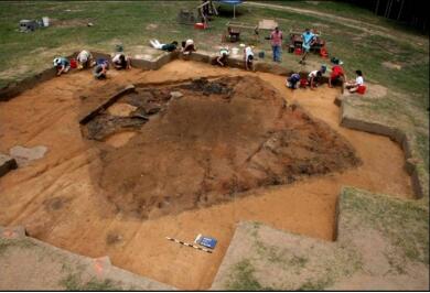
Since 2014 we have removed approximately 240 m² of plowzone from the archaeological footprint of Fort San Juan (Figure 6). These plowzone soils contain similar quantities of Spanish and Native American artifacts as were recovered in the Spanish compound, but the sub-plowzone soils in and around the fort are extremely complex and as yet poorly understood, due primarily to the extraordinary range of activities that took place in this portion of the site before, during, and after the occupation of Fort San Juan. Understanding the social relations of power and resistance embedded within claims and counterclaims to this contested space is a key problem we seek to address through the next phase of our research. Numerous features are visible in the sub-plow matrix, and some of these are quite intriguing. One is a large circular pit in the southwest quadrant of the fort that measures about 1 m in diameter. Significantly, it is surrounded by irregular lenses of water-borne sediment and likely represents a well.
Just north of this feature is a rectangular single-post building (Structure 7) that predates the fort’s construction, as it was intruded by both the northern and western sides of the moat. Several large posts inside this structure probably represent roof supports, and two likely hearth features are located near the center of the building. There are additional features along the northern edge of the fort’s interior, including a thick clay deposit (Feature 254) that extends over an area of 30 m² and is much as 6 cm deep depending on depth of plowing. It consists of a clean, yellow-brown clay found nowhere else on the site. A seemingly intentional deposit, it is also aligned parallel to the rectangular post building. Adjacent to this clay is a midden-like deposit (Feature 255) that resembles the midden we identified in the western portion of the Spanish compound. Interpreting these deposits on the interior of the fort—especially determining which predate, postdate, or were contemporaneous with the Spanish occupation—will require far more extensive excavations, and indeed, this is a challenge that excites us all.
CONCLUSIONS
Columbus’ landfall in the Bahamas in October 1492 initiated what was perhaps the most dramatic century of cultural exchange in human history. Over two continents, the native peoples of the Americas—from Tierra del Fuego to the St. Lawrence River—withstood waves of explorers, settlers, proselytizers, and profiteers from Spain, England, France, Portugal, the Netherlands, and other distant centers of European colonial aspiration. Of these nations, Spain was by far the most ambitious in its early efforts at exploration and conquest.
Together with our previous work in the domestic Spanish compound, our ongoing work on Fort San Juan is providing as comprehensive and robust a view of early colonialism as any other archaeological project in North America. By combining archaeological and ethnohistorical data on the contexts of this early colonial encounter, our research promotes a broadly anthropological understanding of this South Atlantic frontier on the cusp of those political, economic, and material transformations wrought by globalization.
Biographic Sketch
Robin Beck is Associate Professor in the Department of Anthropology at the University of Michigan and serves as Associate Director and Curator of North American Archaeology in the Museum of Anthropological Archaeology. He received his PhD from Northwestern University in 2004. Beck’s research interests include the archaeology and ethnohistory of complex societies in eastern North America and the Andes of Bolivia and Peru, early colonial encounters in what is now the southeastern United States, and the broader issues related to long term trajectories of social change. He is the author of Chiefdoms, Collapse, and Coalescence in the Early American South (Cambridge University Press, 2013), editor of The Durable House: House Society Models in Archaeology (CAI Press, SIU Carbondale, 2007), and co-editor of Fort San Juan and the Limits of Empire: Colonialism and Household Practice at the Berry Site (University Press of Florida, 2016). He has published articles in Current Anthropology, American Anthropologist, American Antiquity, Latin American Antiquity, Historical Archaeology, Ethnohistory, and Southeastern Archaeology and has also contributed to numerous edited volumes. In 2006, Beck received the C. B. Moore Award for Excellence in Archaeology by a Young Scholar in Southeastern Studies. His research has been supported by grants from the National Science Foundation, the National Geographic Society, and the Wenner-Gren Foundation.
David G. Moore is a professor of anthropology at Warren Wilson College, Asheville, North Carolina, USA. He earned a B.A. from the University of California, Berkeley, and M.A. and PhD. in anthropology from the University of North Carolina at Chapel Hill. Following his dissertation investigations at Berry in 1986, he was joined by colleagues, Robin Beck, Christopher Rodning, and Rachel Briggs, for ongoing excavations at Berry. The Berry Site Archaeological Project has been supported by grants from the National Science Foundation, the National Geographic Society, and the School for Advanced Research in Santa Fe, New Mexico. Professor Moore is author of Catawba Valley Mississippian: Ceramics, Chronology, and Catawba Indians (University of Alabama Press, 2002), and co-editor with Robin Beck and Christopher Rodning of Fort San Juan and the Limits of Empire: Colonialism and Household Practice at the Berry Site (University Press of Florida, 2016). He is coauthor of chapters in New Voyages to Carolina (University of North Carolina Press 2017), and The Forgotten Centuries: Indians and Europeans in the American South 1521-1704 (University of Georgia Press 1994), and has authored and coauthored articles in Southeastern Archaeology. He helped to found, and serves as the Senior Archaeologist for, the Exploring Joara Foundation, Inc., one of the largest public archaeology programs in the eastern United States. Over the past six years, the Exploring Joara Foundation has reached more than 14,000 people through public programs at the Berry site, at regional schools, and at museums and other public venues.
Christopher B. Rodning is professor in the Department of Anthropology at Tulane University, New Orleans, Louisiana, USA, and codirector of the Berry Site Archaeological Project. Professor Rodning was graduated magna cum laude from Harvard University with a B.A. in anthropology in 1994, and a Ph.D. in anthropology from the University of North Carolina at Chapel Hill in 2004. He is the 2005 recipient of the annual C.B. Moore Award for an Outstanding Young Scholar in the Archaeology of the Southeastern U.S., and he chaired the program committee for the annual conference of the Society for American Archaeology (SAA) in Austin, Texas, in 2014. He is currently secretary of the Southeastern Archaeological Conference; the book reviews editor for American Antiquity, the journal published by SAA; and editor of the SAA magazine, the SAA Archaeological Record. His book, Center Places and Cherokee Towns: Archaeological Perspectives on Native American Architecture and Landscape in the Southern Appalachians, was published by the University of Alabama Press in 2015, and reissued in paperback in 2019. Rodning is author and coauthor of scholarly papers and book reviews in American Anthropologist, American Antiquity, Historical Archaeology, Southeastern Archaeology, North American Archaeologist, the Journal of Anthropological Archaeology, and other journals, and he has also been author and coauthor of chapters in several scholarly books in archaeology. His scholarly interests in archaeology include topics such as culture contact and colonialism, cultural landscapes, monuments, architecture, ritual and religion, chaos theory, resilience theory, and the history and prehistory of Native North America.
Rachel V. Briggs is a teaching assistant professor at the University of North Carolina-Chapel Hill, USA, in the departments of anthropology and archaeology, and the newest co-director of the Berry Site Archaeological Project. She received her BA from Warren Wilson College in 2005, her MA in anthropology from the University of Alabama in 2011, and her PhD in anthropological archaeology from the University of Alabama in 2017. Her work has been featured in American Antiquity and Native South, as well as other journals and edited volumes. Currently, she is working on a co-edited volume, Mississippian Women (University Press of Florida), which focuses on the dynamic roles native women performed in the late prehistoric period in the Southeastern United States. Briggs’s scholarly interests primarily lie in foodways, gender studies, sensory experiences, experimental archaeology, neurogastronomy, and embodied cognition. In particular, a great deal of her research has focused on maize-based foodways throughout the Southeastern United States, and she is engaged in several on-going research projects that broadly explore the tools, meals, and even sensory experiences of these foodways.