

2019 SAF Discovery Awards|The Keros-Naxos Seaways and the coastal hinterland of the Early Bronze Age sanctuary at Kavos
Introduction
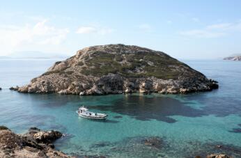
Kavos, at the western end of the small island of Keros in the Cyclades (Fig. 1), was for decades one of the most enigmatic archaeological sites in Greece. New fieldwork has transformed our understanding of the island’s central role in the Early Bronze Age Aegean. Earlier work had already defined Kavos as the world’s earliest maritime sanctuary. Excavation in 2016-2018 on the adjacent islet of Dhaskalio demonstrated the site’s dramatic expansion around 2500BC, with planned monumental constructions and centralisation of craft practices, especially metallurgy. These factors, combined with the exceptional reach of the site (visitors came from as far as the mainland of Greece, some 200km to the west) and changes in the subsistence base, point to incipient urbanisation with major changes in hierarchical and heterarchical social relations. Study and interpretation of the finds, currently ongoing, are changing our understanding of social transformations in the third millennium BC eastern Mediterranean at the crucial point just before the appearance of the palaces of Minoan Crete and the complex social and religious organisations they represent. The analysis of these new data will make a great contribution to understanding the role of ritual practices at periodic meeting places worldwide in catalysing wider social change.

The Importance of Keros
Keros has been known since the late nineteenth century when several marble sculptures of the third millennium BCE were found (now in the Louvre and in the National Archaeological Museum in Athens). In the 1960s Colin Renfrew visited the west end of the island at the suggestion of Christos Doumas and found an extensively looted site that at first glance might have seemed like a cemetery. Rescue excavations carried out by the Greek Archaeological Service in the looted area in 1963 and 1967 recovered much broken marble sculpture, marble vessels, and ceramics. A small survey of the area carried out in 1987 suggested the remains extended beyond the looted area and this provided the impetus for a major research project carried out between 2006 and 2008.
From the first day of excavation in 2006, new finds of broken marble (Fig. 2) in an area untouched by looters offered the opportunity of understanding the nature of a clearly unusual site. The excavations showed that, far from being the remains of a cemetery, these were deliberate deposits of carefully selected broken material. Moreover, in most cases each original object was represented by only a single piece selected after breakage: the breakage had taken place elsewhere, and the site was a place to which people brought material already broken elsewhere, on other islands of the Cycladic archipelago. This long-lived ritual provides evidence for a centre of congregation maintained between island communities over nearly half a millennium, thereby creating the world’s earliest maritime sanctuary.
The 2006-2008 project also focused on excavating nearby Dhaskalio (Fig. 3). This is today a tiny islet located some 90m west of Kavos, but bathymetric studies showed that in the Early Bronze Age it was joined to Kavos by a low-lying landbridge, itself forming a harbour suitable for beaching the canoes and longboats used at that time. Excavations on the summit of Dhaskalio uncovered a series of buildings whose purpose was not clearly domestic. Radiocarbon dates and ceramic typology suggested three phases of occupation: Phase A (2750-2550BCE), Phase B (2550-2400BCE), and Phase C (2400-2250BCE). Most of the activity in the two ‘special deposits’ on Kavos seemed to date to Phase A, while most of the activity uncovered on Dhaskalio seemed to date to Phase C.
In 2012-2013 a pedestrian survey of the island of Keros was carried out in order to understand more about the immediate hinterland of the sanctuary and the agricultural potential of the island. The survey showed that, despite its lack of natural resources and arable land, rather more settlement than might have been expected was located on Keros, strongly suggesting that new farming strategies (particularly the use of terraces, and the expansion of the subsistence base to include the olive and the vine) were employed to improve the agricultural potential of the island. The sanctuary at Kavos and the buildings on Dhaskalio, rather than being entirely isolated, were rather at the pinnacle of a settlement hierarchy established on Keros at the same time as the founding of the sanctuary.
The 2015-2018 Project
New work carried out between 2015 and 2018 both widened and deepened the scope of the investigation of Keros, leading to scalar insights into the inception, floruit and abandonment of the unique site of Keros.
Aims and Method
The aims of the project were to investigate the wider area of the Keros sanctuary and its role in networks of people, resources and materials; and to understand the nature, extent and chronology of the site on Dhaskalio.
In order to approach Keros’ role in the wider Cyclades, two approaches were employed. First, survey was conducted on the neighbouring island of Kato Kouphonisi (5km distant from Keros, and the nearest significant island with agricultural potential), and further distant on the southeast coast of the much larger island of Naxos. The aim here was to extend the area of the Keros hinterland already surveyed on Keros itself by sampling a significant extent of nearby land and creating the first adjacent maritime survey zone in the Aegean. The hope was to be able to understand significant questions, such as to what extent nearby islands were exploited for their resources and particularly for their agricultural potential; how the occupation patterns on Naxos and Kato Kouphonisi might compare with those already established on Keros; and whether Dhaskalio and Kavos were at the top of the settlement hierarchy for the combined area, or whether other significant sites existed in these adjacent areas. Finally, in order to test the results of surface survey, test excavations were planned on two sites identified by survey on Keros.
A second approach to understanding Keros’ role in Aegean networks is through resource and material characterisation studies. It was already established in previous work that all materials and resources used on Keros were imported from other islands or from further afield. New characterisation work on pottery, stone, obsidian and, potentially, on organic resources, might further our understanding of the extent and intensity of material and resource exchange over a wide area.
Focusing on Dhaskalio, important questions arose from previous work which the recent campaign was designed to answer. To what extent was the entire promontory occupied with buildings? What were the origins of the settlement, did it expand evenly or in punctuated bursts over time, and what led to its abandonment? What were the functions of the site, and in particular was the site rather more specialised than a simple domestic settlement?
In order to approach these questions, an entirely new methodology was adopted. The emphasis was on the integration of specialist studies in real time into the excavation methodology and on the dissemination of the data heterarchically throughout the team. To that end, an entirely digital recording methodology was adopted, using the iDig app running on iPads (Fig. 4). iDig was developed for recording excavation data at the Agora excavations in Athens, but we repurposed it so that all data from specialist study could be integrated with the excavation data, thus facilitating reflexivity between specialists, excavators and the executive team. Field specialists such as the micromorphologist and soil chemist recorded their results directly into the same database as the excavators, and field laboratory studies, especially pottery and environmental data, were recorded in the same database. In particular, pottery study was designed so that a small team of six specialists could study material the day after excavation, thus giving excavators immediate feedback on the nature of the contexts they were excavating.
Excavation in the field was undertaken using the open-area, single-context system. The open-area approach was important in that large trenches were necessary in order to understand the nature of the architecture of buildings and complexes, and the way that routes of movement were set between buildings and through the underlying terraces built to support the architecture. The single-context approach was essential in order to understand the taphonomic history of the site and individual rooms, and in particular to develop the stratigraphic understanding of the site. Replacing the traditional open-area and single-context reliance on plan drawings, a volumetric recording method was effected using digital photogrammetry. Every context was recorded photogrammetrically, creating a vast 3D archive of the excavation, and allowing the review of each step in the excavation by examining the 3D model of each context.
Results and Interpretation
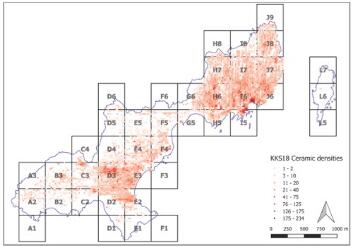
The surveys on Naxos and Kato Kouphonisi (Fig. 5) showed that, as on Keros, the Early Bronze Age was one of the three periods during which these islands were most inhabited (the other two being the late Roman-Early Byzantine period, and recent times). However differences were detected. Kato Kouphonisi appears to have been as densely inhabited as Keros during the Early Bronze Age. Southeast Naxos, however, shows a less dense occupation pattern. Both areas have important sites, though none as large as Dhaskalio. This suggests that Dhaskalio and Kavos were by some distance the most important and largest sites of the period in this wider area, but that second order sites were present on Naxos and Kato Kouphonisi. Study of the ceramics will prove invaluable in comparing the entirely imported ceramics of Keros with the proportion of local to imported ceramics in the two adjacent areas.
Nine excavation trenches were opened on Dhaskalio, the largest covering 25m x 9m (Fig. 6). The planners and builders of Dhaskalio constructed a series of massive terraces to create flat spaces for building, since the incline is steep all over the island. Our trenches were placed to investigate these constructions at several levels on the north and east side of the island (Fig. 7). Architecturally impressive features were uncovered in all of the trenches. These included major entranceways, one of which appears to be the main entrance of the site (Fig. 8), leading up from the causeway between Dhaskalio and Kavos, formed of a set of stairs piercing a monumental terrace wall. Similarly the route to the summit through the most monumental of the upper terrace walls is formed by a set of stairs in a massively built corridor. Elsewhere paths were made of flagstones, with a small square forming one nodal point (Fig. 9) and a monumental stair set forming another. Complex drainage systems were found in several trenches. These features suggest a pre-planned complex consisting of concentric terracing systems which created level areas for the construction of buildings.
The greater part of the area excavated falls within Phase B, and this is an important discovery of the excavation: the remarkable explosion of building activity that characterises Dhaskalio occurred during Phase B. Overall the excavation of 2016-2018 has uncovered some 551 square metres, much of it excavated to depth, revealing underneath collapsed stone the walls of the buildings, their floors, the material remains of the activities carried out there, and in many cases earlier floors or even earlier architecture. Building stone was imported from Naxos, some 10km distant. This hazardous journey was repeated many hundreds of times to obtain the required material, comprising at least 5000 tonnes of imported stone. The quality of the constructions, the degree of planning they evidence, and the amount of labour required to realise them, has opened a new window onto the nature of the society which we are investigating. The massive building terraces with entranceways and drainage systems show a vision for the planned construction of the whole promontory – a plan that was evidently achieved, with buildings extending over an area of about 1.3 ha, the largest site of its time in the Cyclades.
Evidence for the nature of the occupation comes from the types of activities which can be detected. The most important of these is metallurgy (Figs. 6, 10). It is one of the most remarkable aspects of the work on Dhaskalio that evidence for metalworking was found in every trench, with different technical processes represented. It would appear that metallurgy was the earliest activity on Dhaskalio, with metallurgical hearths set in the bedrock underneath later remains in three trenches. These were for the melting of copper and the casting of objects. Moulds for spearheads (Fig. 10) and daggers have been found. Later, when the constructions covered the island, extensive workshops were located in two trenches. Lead and perhaps silver working is evidenced alongside copper, while gold – extremely rare in the Early Bronze Age Cyclades – was found in five trenches, including gold wire probably used for finishing metal artefacts, and gold foil. Both the intensity of evidence for metalworking, and the range of activities, is unprecedented in the early Cyclades. We have only begun to understand all the implications of the nature of the site at Dhaskalio for wider Aegean society, mobility, identity and power.
Overall, the excavations and the associated surveys have opened a window onto a changing world. New modes and media of information exchange were deployed in networks that came to be sustained by acts of congregation at a central point, Keros, where a new vision for society was crafted. We can recognise now the place of Keros in a certain historical trajectory of the third and second millennia, where Keros represents, along with Knossos on Crete, the very first premonition of the central places that would become common just a few hundred years later. Prior to the inception of urbanisation in the Aegean on Crete after 2200BC, its antecedents may now be recognised here at Keros. A number of factors combine in a unique foreshadowing of the processes of urbanisation soon to take place elsewhere: centralisation, whereby one centre stands out above all contemporaries; exceptional reach, where members of far-flung communities were drawn into networks centred on Keros; intensification, evidenced in spheres such as metal production, agriculture and architecture; aggrandisement, seen in exceptional architectural programmes which are monumental by prevailing standards; and a strong ritual component, drawing in participants from far and wide and underpinning all the other processes. The evidence also suggests that new means of forging and maintaining a particular Cycladic identity were centred on Keros. Key elements in this identity included Cycladic sculpture, the ‘icon’ of the Cyclades, along with important practices such as seafaring and metalworking, and in particular the production and use of daggers on Dhaskalio.
Conclusion
Until recently, our picture of the Cycladic Early Bronze Age was based largely on cemetery excavations, hurried rescue excavations, and dubious looted material. Work on Keros has completely changed this picture. The Keros-Naxos Seaways programme is characterised by a commitment to full publication of an ambitious project, wide in its scope, with the participation of inter- and multi-disciplinary specialists, in four volumes and numerous academic articles. Much has been learned about Keros and the Early Cycladic world which brought it into being and which it changed beyond recognition. This has recently come to public attention through press articles, documentaries and a recent museum exhibition (Fig. 11). The publication programme will take all of our energy for the next two years, and then we will hope to expand our work further. Only about 10 per cent of the Dhaskalio site has been excavated so far, and many further insights into Early Cycladic life must surely remain below its surface.

Biographic Sketch
Colin Renfrew received his doctorate in 1965 from the University of Cambridge. After the post as a Lecturer and then Reader at the University of Sheffield (1965-1972) and the Professorship at the University of Southampton (1972-1981), Renfrew was elected in 1981 to the Disney Professorship of Archaeology at the University of Cambridge, a post he held until 2004. Professor Colin Renfrew has directed a number of major excavations on the Cycladic islands in Greece. He has made remarkable contributions to Aegean prehistory, origins of linguistic diversity and human cognition, archaeogenetics, and archaeological theory. In addition, Professor Colin Renfrew has been one of the leading figures in the international movement to prevent the illicit antiquities trade and associated looting of archaeological sites. Professor Colin Renfrew has authored numerous books; among them are Before Civilisation: the Radiocarbon Revolution and Prehistoric Europe (1973); Archaeology and Language: The Puzzle of the Indo-European Origins (1987), Archaeology: Theories, Methods, and Practice (with Paul Bahn, 1st edition, 1991; 7th edition, 2016); Loot, Legitimacy and Ownership: The Ethical Crisis of Archaeology (2000); Prehistory: The Making of the Human Mind (2008); and many co-authored books. Professor Renfrew’s eminent career, made up of both important excavations on the Cycladic islands, influential theoretical insights, and tireless and dedicated efforts in raising public awareness about our endangered cultural heritage, has been rewarded with many distinguished honors, awards and prizes. Among them are Fellow of the British Academy (1980), a life peerage as Baron Renfrew of Kaimsthorn (1991), Foreign Associate to the National Academy of Sciences of the USA (1996), the Latsis Prize of the European Science Foundation (2003), the Balzan Prize (less well known than the Nobel but equally prestigious, 2004), Foreign Honorary Member of the Archaeological Institute of America (2007), and the SAFE Beacon Award (2009). Professor Colin Renfrew was presented to the first SAF Lifetime Achievement Award in 2015.

Michael Boyd is a senior research associate at the McDonald Institute for Archaeological Research at the University of Cambridge. His main research interests lie in the prehistoric Aegean where he has worked in the Peloponnese and Cyclades. He is co-director of the Keros-Naxos Seaways project, and co-editor of the Keros publications series. He has worked widely in Greece, Bulgaria and Albania. He is co-author with John Barrett of the volume From Stonehenge to Mycenae: the challenges of archaeological interpretation. He is co-editor with Colin Renfrew and Iain Morley of a volume on the archaeology of death and burial from a worldwide perspective, and another on the parallel development of play and ritual. He is also co-editor with Anastasia Dakouri-Hild of Staging Death, and is co-editor of Early Cycladic Sculpture in Context, with Marisa Marthari and Colin Renfrew, and Beyond the Cyclades. Since 2008 he has worked with Colin Renfrew on the publication of the Keros excavations of 2006 to 2008, of which he is co-editor. Four of a planned five volumes have now been published. He is also editing the publication of the Keros Island Survey, carried out and completed in 2012 and 2013, and due to be published in 2020. He is co-director of the Keros-Naxos Seaways project, involving excavation on Keros (2016-2018), survey on Naxos (2015), and survey on Kato Kouphonisi (2018). Fieldwork was completed in 2018 and publication will follow in four further volumes.